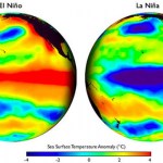
El Nino
Greenhouse gases go up and down in three ways.
First, there is the annual up and down cycle that happens because there is more land in the Northern Hemisphere. I won't explain that to you now because I know you can figure out why that happens.
Second, there is natural variation up and down aside from that annual cycle that has to do with things like volcanoes and such. This includes the rate of forest fires, which increase greenhouse gases by turning some of the Carbon trapped in plant tissue into gas form as CO2. (That was a hint for the answer to the first reason!)
Third, humans.
There was…
It is like that stabby lady in the bath tub in that movie.
Here, I'll give you a more readable version of the graphic from NOAA:
The chance of an the Pacific ENSO system being neutral, meaning, not adding extra heat to the atmosphere and not removing extra heat form the atmosphere, is about 50% from now through mid 2017.
But, the chance of a la Nina is pretty darn low, and the chance of an El Nino, which would add more heat to the atmosphere than the average year, is not only approaching 40% but it has been growing.
A second El Nino this close on the last one, which was a very severe El…
On Significant Figures, Peter Gleick explains that growing populations worldwide have exerted peak pressures on water supplies, leaving entire regions more vulnerable to natural variations in rainfall. In turn, global warming has made these natural variations more extreme. One such variation is El Niño, when "droughts are typically more widespread and severe." Dr. Gleick reports on the challenges faced around the world in 2016, as several historic droughts grow worse. Meanwhile, in honor of Earth Day, Ethan Siegel suggests we count our blessings: "there’s still no planet as friendly to life…
Though not enough. And for the wrong reasons. But this is still good news.
Somewhere around 1990, but you could justify an earlier date if you like, science knew enough about global warming, the increase in the planet's surface temperatures caused by human release of greenhouse gas pollution and other human effects, to have initiated meaningful action to shift our energy supply away from fossil fuels. We didn't know exactly what would happen, but we knew stuff would happen. How long has it taken for this science to turn into effective policy to address global warming? We don't know, because…
The US NOAA has this video summarizing what they expect for weather in the US as the result of the current, winding down, El Nino:
(function(d, s, id) { var js, fjs = d.getElementsByTagName(s)[0]; if (d.getElementById(id)) return; js = d.createElement(s); js.id = id; js.src = "//connect.facebook.net/en_US/sdk.js#xfbml=1&version=v2.3"; fjs.parentNode.insertBefore(js, fjs);}(document, 'script', 'facebook-jssdk'));
2016 Spring Climate and Flood Outlook
As a near-record El Niño begins to wind down, NOAA issued its spring seasonal outlooks for flooding, drought, precipitation, and…
The latest episode of Ikonokast, the science podcast Mike Haubrich and I do, is now up. This is an interview with Pacific Institute's Peter Gleick. We talk about the California drought (past, present, and future), Syria, virtual water, El Nino and climate science denialism.
You can hear the podcast here: WHAT ABOUT WATER? DR. PETER GLEICK OF THE PACIFIC INSTITUTE.
The Time Scales of Political and Climate Change Matter
The US is engaged in the laborious process of electing a new leader, who will likely be President for 8 years. Climate change has finally become an issue in US electoral politics. The climate policies of the next US President, and the Congress, will have a direct impact on the climate, because those policies will affect how much fossil carbon is put into the atmosphere over coming decades. So it is vital to consider what the climate may do during the next administration and the longer period that will include that administration’s…
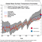
The year that just finished, 2015, was the warmest year recorded in the instrumental record. The actual data for December is not officially available yet, but my friend and colleague John Abraham keeps track of the global surface temperature daily and has done an amazing job at estimating the final temperature anomaly value that is eventually reported in each of several databases. He has provided a graph using his estimated value, above.
There are two major contributing factors, maybe three depending on how you count everything, to 2015 being the warmest year. The main factor is, of course…
Despite the devastating storms across the country the last few weeks, NASA is forecasting the worst is yet to come. Michael Mann, author of "Dire Predictions: Understanding Climate Change" joins to discuss.
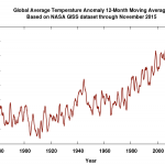
The NASA GISS global temperature anomaly for November has been published.
October's value was originally reported as 104, but has been corrected (it is normal to have small corrections on an ongoing basis) to 106. November's value, just out, is 105.
This is hundreds of a degree C anomaly, the standard number used to report, off of a baseline. The baseline in the case of NASA GISS is 1951-1980, which does not represent pre-industrial levels.
The huge uptick we saw during the last part of the current year is the result of global warming, which has been pushing temperatures up, and the…
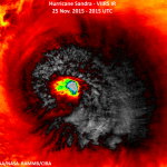
Sandra is a Category 4 hurricane in the Eastern Pacific. The storm will hit Mexico.
Sandra breaks several records. It is the first observed Category 4 hurricane on Thanksgiving Day. It is the latest major Western Hemisphere hurricane observed. It is the latest Category 4 storm in either the eastern Pacific of Atlantic basins. Most likely, Sandra will become the latest landfalling tropical cyclone on record for Mexico.
(Jeff Masters has details.)
Sandra will come near the southern time of the Baja late Friday, but will likely be a tropical storm at that point. The storm will come ashore…
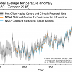
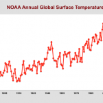
The World Meteorological Organization has announced that they expect 2015 to be the warmest year on record, and that we are in the warmest five year period on record. We are speaking here of global surface temperatures, though similar descriptions probably apply to the upper 2000 meters or so of the ocean as well.
The global average surface temperature in 2015 is likely to be the warmest on record and to reach the symbolic and significant milestone of 1° Celsius above the pre-industrial era. This is due to a combination of a strong El Niño and human-induced global warming, according to the…
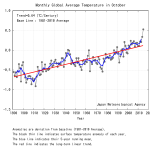
The Earth's surface is warming primarily because of human generated greenhouse gasses, mainly CO2, being added to the atmosphere. Several agencies and organizations track this by combining data from surface thermometers and sea surface temperature measurements. The Japan Meteorological Agency is one such group, and they have just released their updated monthly data for October.
The graph above shows the average surface temerature for the month of October for the entire period of their data set (1891 to the present). Not only is October 2015 the warmest October observed, but it is way…
John Abraham is a scientist at St Thomas University in the Twin Cities. John is famous for doing battle with a famous science denialist (that's what the meme above refers to), for his blog at the Guardian, for his research in several areas such as ocean heat, and for keeping track of month by month increases in global surface heat caused by anthropogenic global warming.
Sunday, I had the honor of interviewing John Abraham about current developments in climate change. It was Sunday morning so you were probably either sleeping or in church, but don't worry, there's a podcast!
You can listen…
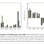
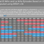
A new study seems to provide a better way to categorize El Nino climate events, and offers an explanation for how different kinds of El Nino events emerge.
El Nino is part of a large scale, very important climate phenomenon in the Pacific Ocean, generally referred to as the El Nino Southern Oscillation (ENSO). Over time (years) wind and water currents move heat into the upper levels of the Equatorial Pacific (La Nina). Then, over time (months) the heat comes back out – that is an El Nino. The effects can be dramatic. During El Nino years, trade winds and monsoons may behave differently than…
Officially, 2014 closed without an official El Nino. Probably. If you went back in a time machine to the spring, and told El Nino watchers that, they would be a little surprised, but they would also say something like, "Yeah, well, you know, we keep saying this is hard to predict."
Despite the fact that for the most part there was not an official El Nino declared, a subset of El Nino conditions have been around, off and on, for many months. To officially declare an El Nino, a number of things have to add up, and while some of those things developed, the standard was not met. A few weeks ago…
The Road to Paris is a web site created by the ICSU, "...a non-governmental organization representing a global membership that includes both national scientific bodies (121 National Members representing 141 countries) and International Scientific Unions (30 Members)," founded in 1931. If the ICSU had not existed when the UN was formed, the UN would have formed it. Think of the ICSU as the UN of Science. More or less.
(Follow Road to Paris on Twitter.)
Anyway, Road to Paris refers to the 2015 international meetings on climate change, and the purpose of the web site is to provide excellent…
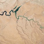
On Significant Figures, Peter Gleick examines the rather relaxed attitudes of some Californians to an extreme drought fostered by three years of dry weather. Gleick writes “reservoirs are at record low levels. Deliveries of surface water to some farmers are lower than at any time in recent history. Streams are drying up and fisheries are being devastated.” Yet he and millions of other residents have been able to run water from their taps freely. Agriculture might only suffer losses of 4% (about .0008% of the state’s total economy). And an expectation of El Niño rains obscures the…
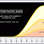
Usually when I make a sentence like that it is about my wife, Amanda. But this time we're talking about Hurricane Amanda, the first hurricane of the Eastern Pacific hurricane season.
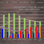
Amanda reached maximum winds of 155 mph on or about 8:00 AM Pacific Daylight Time on Sunday morning. That make Amanda the strongest Eastern Pacific May Hurricane on record. There are usually very few hurricanes in the Eastern Pacific in May, and the few that occur happen late in the months. Here's the historical distribution of Eastern Pacific hurricanes, form 1966-1996:
Amanda is the earliest on record…
The weatherologists have more or less stopped saying there might be an El Niño this year. Now they are saying there will be an El Niño, and they are starting to consider how strong it will be. Well, actually, they've stopped doing that too and are now talking about whether it will be a mondo-El Niño or a mondo-mondo-El Niño.
Here is a newly released video by Peter Sinclair and the Yale Climate Forum about the coming El Niño:
I have a prediction to make. First a bit of background.
You know about the so-called "hiatus" in global warming, because every Tea Partier with a mouth is yammering…