
See below for update.
You may not have even noticed it, but hurricane season has officially started in the Eastern Pacific. That is because the official date of the start of season is May 15th, though the actual hurricanes rarely get the memo and start whenever they want, but usually after that date. Last year's Eastern Pacific season was much ore active than usual. The average numbers for named storms, hurricanes, and major (above Cat III) hurricanes for this basin are 15.4, 7.6, and 3.2. Last year's season was predicted to be pretty much average, but it turned out to be exceptional, with 22 named storms, 16 hurricanes, with 9 major. In addition, there were other notable features such as several storms forming early, two early storms reaching Cat 4 strength, and one storm being the strongest ever recorded in May in the region.
What about this year? The only prediction I've seen suggests a somewhat more than average season (19 named storms, 11 hurricanes, with 4 major). So far there are no named storms, but there is one disturbance that is likely enough to turn into one that I thought this would be a good moment to start paying attention, thus this post.
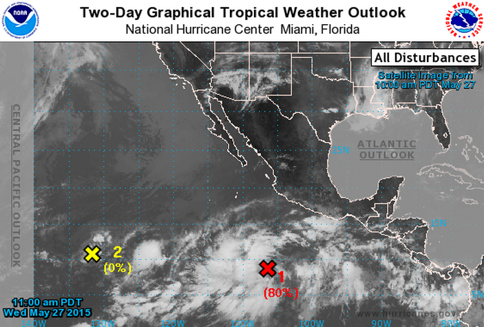
The stormy system is currently known as Disturbance #1, and it is sitting in the pacific south of Mexico. The National Weather Service calculatges a 20% chance of this disturbance becoming a tropical cyclone over the next 48 hours, but an 80% chance over the next 5 days.
If Disturbance #1 becomes a named storm, it will be christened "Andres," a previously unused name.
Fewer hurricanes that form in the Eastern Pacific hit land than for most other basins, and they very rarely hit the US or Mexico.
UPDATE (27 May 1:51 Central)
Disturbance 1 is developing. The National Weather Service says this disturbance has an 80% chance of forming a tropical cyclone over the next 48 hours, and a 90% of doing so over the next five days. Again, it will be named Andres if it becomes a named storm. Here's what the region looks like (The red X is Disturbance 1):

UPDATE (28 May 12.27 Central)