
A weekend in the Peaks for family purposes, and to our great surprise just around the corner was a rather nice cliff. It is very tucked away and rather takes you by surprise. Here's the google maps link. If you scroll out a bit you'll see "Wheeldon Trees Farm holiday cottages" where we stayed, and which has a convenient footpath running down from the right to the cliff (and if you scroll out a bit further you'll see the giant limestone quarry which shows up far better from above; on the ground you hardly see it). Just south - Longnor - is the Dove valley - beware: the pubs don't open until 12.

So here is the cliff, or rather the central portion of it. Dots are the route, arrows are the belays, but I didn't need to tell you that. "Miranda's delight" is an HVD arete, that ends with a little duck L into the corner because the very top of the arete is compact and gearless; probably around VS to top out on the straight line. I suppose the rock must be limestone (it is an old quarry, now owned by the BMC, though curiously the BMC website doesn't mention that), reasonably weathered and faded, not much polished. It seems to be a quiet venue; many of the lines could do with a bit of gardening. Out of shot to the far right there were more weeds and brambles, and a warning sign noting that it was an old quarry and that bit wasn't necessarily considered safe. But out bit was much cleaner. When we were there it was very dry; after some rain it might get muddy. I know that route is HVD because someone showed us their guidebook, but I didn't remember the real route name. 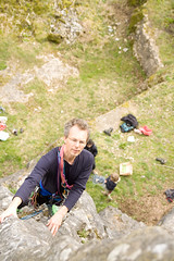 The children happily seconded the arete; with a rope above you it really isn't hard. The pic to the right is by Dan Lane, who does climbing photopgrahy (see danlanephotography.com/) and does quite a good job of making me look heroic as I contemplate the steep arete.
Miriam's downfall (S, 4a) is the obvious crack. From where I've taken the photo it is clear that the angle is fairly easy, but what you can't see is that the other side of the corner forces you somewhat out of balance at about half height and above. Both routes have good solid trees to belay on. It is a nice route, just a little bit dirty and a little bit polished at some of the more obvious holds, but a pleasant severe and a good start to the "season" (I put season in brackets because I know I'll be lucky to climb again this year :-().
What isn't so obvious from these pix is that there is a good deal of rock elsewhere. Lets have a wider look:
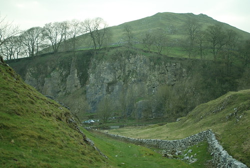
The previous pic showed the rock roughly under the high point of the clifftop; from this pic you can see that the face on the L of the top pic goes up much higher. The lower part of that face is compact and looks Hard; but the upper tier (which you might reach up the HVD) looked more crack-y, but possibly less easy angled.
Anyway, a very nice little find I think, we'll try to go back. We may have exhausted the easy climbs on the cliff - from there it looks to be VS and up, unless you top-rope.
"Printapons" are available for restaurants, recreation activities, entertainment, and drinks. Start saving with your coupons today
no comments on Oxford's triumph?
[I got to watch it on TV, a good solid race, and an excellent victory for the Good Guys. Hurrah for Oxford! -W]
Very good. It'll ease the pain of England's humiliation in cricket, though you've never mentioned cricket so perhaps you don't care.
Just for the information, www.multimap.com (now subsumed into Bing) has OS maps online. Only 1:50,000 but a nice way of showing landmarks etc.
@carrot eater: it was one day game. They don't count. :)
Are there any karst features nearby? A few potholes or caves would make the landscape even more interesting :) And the mountainsides could use a bit of trees to keep the remaining topsoil in place. I assume this would have been woodland up until ca. the 18 century. Did you run into any birdwatchers?
@Birger Johansson - it's fairly classic limestone country. See https://secure.wikimedia.org/wikipedia/en/wiki/White_Peak for a bit more on it.
Re. link at 5:(grandpa Simpson) -Matlock!? What is *he* doing there???
Anyway, I wonder if some truckloads of richer topsoil could create a bit more tree/bush landscape, providing habitats for the lower part of the food chain. After that, we can implant some mustelids as local top predators :)
I nearly drowned in the Google map link, you have a tremendously history-rich country squeezed into a very small area, like squeezing Italy into Luxemburg. And the patch of landscape in the image is surrounded by big cities, temporarily kept away by the hills. If the "Wheeldon Trees Farm holiday cottages" add some conference rooms, they should be able to pull in lots of people.
I assume this would have been woodland up until ca. the 18 century. Did you run into any birdwatchers?
[Nope. The surrounds are fairly moorland-sheepy nowadays, indeed our cottages got the name "Trees" apparently for having just a few -W]
As a youth, reading Brown & Whillans tales, or poring over John Cleare photos, left me with a fascination about cliffs I've never seen (save one high-adventure day at Boulder Ruckle). Charming photo, conveys that very British sense of the crags!
hi William
I have seen you Dinas Cromlech photo on the web. I am writing a book on famous climbing teams for an italian publisher. I am interested to publish you photo to illustrate the Joe Brown-Don Whillans team because of their route there. I need authorization for publication and agree fees. Can ypu please come back to me by email?
Bst
Alessandra Raggio