evacuations
We've arrived at Friday. The local time is 8:45 A.M. Set your watches accordingly.
Batur, Indonesia
Some news!
More evacuations have been authorized near Mayon as the volcano continues to show signs of significant eruption. Activity has quieted some since Tuesday's explosion, but PHIVOLC still expresses concern that an eruption in impending within weeks. I'll also add a link to this story on Mayon, not because it has new news, but because it has quiet possibly the worst accompanying photo for this story I've seen so far. I mean, really, couldn't you have found some stock picture of Mayon…
Mayon volcano in Albay province, Philippines.
Yesterday, Mayon in the Philippines, which has been showing signs that it might be headed towards a significant eruption, produced an ash plume that reached as high as 3.5 km / 12,000 feet according to some reports. Evacuations of villages near the volcano have begun, while many other towns have been supplied with wireless announcement systems to help with evacuating if the volcano continues to show signs that it will experience a significant eruption.
Last week, there were reports that a new dome was forming at the summit of Mayon and if this…
I'll be giving a talk this afternoon here at Denison on rhyolite generation, so I might be a little brief this morning.
Undated image of Mayon in the Philippines.
The province of Albay in the Philippines is on alert for both a typhoon and a volcano (that country seems to be hit with that 300,000 may need to be ready to evacuate if the volcano continues to show signs that it might erupt - in fact, Mayon is producing ash as of this morning, albeit only one minor ash explosion.
Lava flows from Kilauea are drawing crowds as they inundate a road in Kalapana. There is a nice video link to the…
I did an excellent job of forgetting my notes from GSA 2009, so no wrap up on the meeting until tomorrow, but we do have some new volcano news to digest:
The crater of El Reventador in Ecuador in an undated photo.
Ecuadorian officials have called for evacuations around El Reventador. The Ecuadorian Geophysics Institute says that the volcano's "activities were measured at a level considered high, with permanent seismic signals indicating explosions while the southern side of the volcano crater could be seen as incandescent.". Three provinces near the volcano were put on alert evacuated as a…
San Cristobal in Nicaragua
I don't have much in the way of details, but the Associated Press is reporting that San Cristobal in Nicaragua has erupted this evening. The volcano reportedly experienced an explosive eruption and that nearby villages (how nearby is unclear) have received ash fall from the eruption. If it is any indication, government officials did issue a warning to 25 districts around the volcano and so far no casualties have been reported.
UPDATE 8:30 AM (EDT) 9/7/2009: A few more details have come out about the eruption. The ash plume reached ~8,000 m / 26,000 feet, although…
Some more volcano news for the day ...
UPDATE 10:40AM Eastern: It has been pointed out to me that both of these articles are old. They apparently made it into my Google News feed thanks to a glitch in the magic interweb tubes somewhere. Just goes to show that blogging before coffee on a Monday after traveling across the country = bad idea. Sorry for any confusion.
A summit dome at Kelud during the 2007 eruption.
OLD NEWS ABOUT SARYCHEV PEAK IN JUNE 2009. An unnamed Russian volcano in Kamchatka is disrupting flights from Canada to Asia. No ID in the article on which volcano, and I couldn't…
Some of the articles you might have missed this week ...
A lava flow from Kilauea breaks local traffic laws in the Royal Gardens subdivision, Hawai'i
The Mayon Watch continues in the Philippines. No eruption yet, but some of the local newspapers are printing stories talking about "odd animal behavior" and other local "myths" about predicting the volcano, such as the wells drying up. Now, this is not to say that these things might have some predictive value (especially changes in the water table near the volcano as it inflates/deflates), but so far there are no robust scientific studies that…
Mayon erupting in August 2004.
The increasing unrest at Mayon in the Philippines has prompted National Disaster Coordinating Council (NDCC) to recommend the evacuation of over 75,000 people from around the volcano. This, however, will only happen if the activity at the volcano continues to increase. The volcano currently sits at Alert Level 2 (increasing unrest) and if it were to increase to Level 3 (increased tendency towards eruption), then the evacuations of the first ~1,800 families closest to the volcano would begin. Only if the volcano reached Alert Level 4 (hazardous eruption imminent…
Another fun weekend for me analyzing zircon on the SHRIMP-RG at Stanford University! I really know how to live it up during the summer.
Some news bits:
The 2009 dome at Redoubt in Alaska steaming on July 2, 2009. Image taken by Cyrus Read, courtesy of USGS/AVO
In another sign that Redoubt's 2009 eruption might be at an end, AVO has ceased 24 hour staffing of their operations center. They still warn that Redoubt might still have more activity up its sleeve, but as of now, things are pretty quite. The latest update on Redoubt reports that the new dome continues to steam away and seismicity…
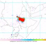
Three days ago, I received an email from Eruptions reader Gijs de Reijke who was curious about something he noticed in the daily OMI SO2 images:
OMI sulfur dioxide map over Ethiopia for June 30, 2009.
Now, I wasn't quite sure what to make of it other than the fact that there was an awful lot of sulfur dioxide in the vicinity of Addis Ababa, which seemed odd. If we look at a map of the active volcanoes in Ethiopia (below), a majority of the ones we might suspect if the SO2 was volcano are to the north (Erte Ale, Dallafilla), but this patch is smack-dab in the middle of the country, looking…
The Q&A post will be coming over the weekend (there's still time to send me a question!)
Icy cold volcanoes (well, geysers) on Enceladus, a moon of Saturn.
In the meantime, here are a few quick hits:
Mt. Cleveland in the Aleutians had a small eruption. The plume was only ~15,000 feet / ~3 km. Cleveland is one of the more active volcanoes in the Aleutians, so this eruption is not out of the norm.
Landslides and rockfalls at Arenal (in spanish) in Costa Rica continue to prompt evacuations of tourists near the volcano. It is interesting to note that officials don't seem worried about hotel…
Arenal in Costa Rica, erupting in July 2007. Image courtesy of Arenal.net.
Arenal in Costa Rica is one of the most active volcanoes in Central America. It is almost one of the most picturesque (see above) and, dare I say, touristy, volcanoes in the world. However, even volcanoes that seem "benign" like Arenal require special precautions.
Yesterday Arenal has two small eruptions that were accompanied by unusual tremors, (in spanish) according to Javier Pacheco of the Volcanological and Seismological Observatory of Costa Rica (OVSICORI). The tremor started at 7 AM and continued until 4:30 PM,…
Sarychev Peak in Russia erupting on June 14, 2009. Image courtesy of the NASA Earth Observatory.
The transpacific air routes over the Aleutians, the Kamchatka Peninsula and the Kuril Islands are a prime location for the threat of ash to commercial aviation. Many of these volcanoes, especially on the western side of the Pacific Ocean are not closely monitoring and sometimes only remote sensing techniques can keep track of the activity.
Case in point is the current eruption at Sarychev Peak in the Kuril Islands. The volcano is on one of the southern-most Kuril Islands (Ostrov Matua) in Russia…
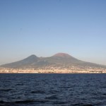
The latest in my Volcano Profiles Series, we turn to Europe and Vesuvius. You could fill many, many volumes with the works produced on Vesuvius since Roman times. This profile will barely scratch the surface when it comes to the vast geologic and human history surrounding the volcano, but it is a start. If you want to learn more about the archaeology surrounding Vesuvius, try visiting Blogging Pompeii.
VOLCANO PROFILE: MT. VESUVIUS
Mt. Vesuvius in Italy. Image courtesy of Dario Leone.
Location: Italy
Height: 1,281 m / 4,203 ft
Geophysical location: The tectonics in the Mediterranean are…
One brief note before I head out the door ...
Fissures formed in western Saudi Arabia during the earthquake swarm near Harrat Lunayyir during May and June 2009. Image courtesy of Ahmed Al-Hussaini.
The earthquakes in the Harrat Lunayyir region of western Saudi Arabia seem to be like a character out of Monty Python and the Holy Grail: they're just not dead yet. Two more earthquakes, these in the M3 range at 8-9 km depth, hit Thursday morning, further delaying the return of evacuees to the Al-Ais region. This bring the total earthquakes to over 150 since seismicity began a few weeks ago.…
Fissures formed by seismicity in the Al-Ais region of Saudi Arabia. Image courtesy of Ahmed Al-Hussaini.
Although it seemed last week that the earthquakes in western Saudi Arabia were subsiding last week, there have been a number of reports that there was still significant seismicity in the area over the weekend. Earthquakes in the M2.5-3.5 range occurred on Saturday - both of which the SGS are attributing to "subterranean volcanic activity." This has prevented the evacuees from the Al-Ais region to return to their homes. The Saudi government has begun to assess how much effect this activity…
Karangetang in Indonesia erupting during the mid 1990s. Image courtesy of VolcanoWorld.
The alert level at Karangetang, one of the most active volcanoes in Indonesia, was raised to Orange over the weekend and people living near the volcano have been evacuated. The volcano is apparently already producing ash and lava flows, but it is mostly the ash hazard that is prompting the evacuations. Karangetang erupts almost every year and sometimes with deadly consequences, as in 1992 when 6 settlers near the volcano perished.
Al-Qider volcano in western Saudi Arabia. Image courtesy of Ahmed Al-Hussaini.
After a week's worth of worry, it appears that the seismicity in western Saudi Arabia is subsiding. The latest statement from Zuhair Nawab, the head of the SGS, is that over the past four days with fewer and less severe aftershocks. If this continues, people who have evacuated the area around Al Ais might be able to return to their homes in a few days. However, it is important to note that even though officials suggest the seismicity is waning (and there may be indications this is not entirely accurate), the swarm…
UPDATE 5/21/2009 4:30 PM Pacific: The latest news suggests that there are little to no evidence of volcanic gases since Wednesday according to the SGS, but they continue to monitor.
Lava flows from a 1256 A.D. eruption near Medinah in Saudi Arabia (to the south of Harrat Lunayyir) taken by the crew of the ISS in 2004. It shows nicely the volcanic heritage (dark lava flow on right of image) in western Saudi Arabia. Image courtesy of JSC Earth Observation Lab.
Well, as the days go by, there are more and more indications that an eruption is about to occur in the Harrat Lunayyir region of Saudi…
Al-Qider volcano in western Saudi Arabia. Image courtesy of Ahmed Al-Hussaini
The intense seismicity occurring underneath the Al-Eis region in Saudi Arabia has reached a point where Saudi Arabian officials are requiring 60,000 people who live in the region to evacuate. This is after M4.6 and M5.4 earthquakes that occurred Tuesday night (Saudi time). Saudi officials have also begun to build shelters for people affected by the earthquakes.
Now, the direct connection to a potential eruption is still very much in the air, but the earthquakes are still centered underneath known Holocene volcanic…