Google Earth
Termite mounds visible in Australia's Northern Territory- I've circled three, but dozens are in the image.
Central Illinois still resembles the frozen lifeless tundra, so to get my bug-hunting fix I've been surfing about on Google Earth. Here at -13.066783, 130.847383 I've found something: Australia's magnificent magnetic termites. The green things are trees, but the little black pimply bits? Those are the termites. On the ground they look like this:
A magnetic termite mound in north Queensland, Australia.
Why "magnetic"?
The mounds are shaped as thin blades along a north-…
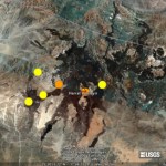
I have finally gotten together enough to create a Google Earth image (below) of the location of the Saudi Arabian earthquakes and their depths/magnitudes. I only have the data from the USGS earthquake list, but it is very illuminating:
Harrat Lunayyir volcano in western Saudi Arabia from Google Earth with the current earthquakes shown on the image. Image courtesy of Google, earthquake data from the USGS. Click here to see a larger version.
The earthquakes look like this (all times are Universal Time):
Date Time Mag. Depth
5/17 19:50 M4.6 10 km
5/19 06:38 M4.9 10 km
5/19 16:54 M4.9 10 km
5/19…

Check out this concept artwork called "Office Grass". What is it good for? Well, for one thing, to patch its apparently coincidental inverse artwork, "Dead Pixel in Google Earth:"
Messor capensis nests, as seen by The Google
Over at Photo Synthesis, commentator Kate directs our attention to Messor capensis, a South African seed harvester whose nests from the air look like some form of fungal growth. Except much, much bigger. (coordinates here: 33° 36â57.32âS, 22° 08â06.38âE)
I've only got one really crappy photo of the beast, but I'll subject you to it anyway:
More Google Earth ants here and here.
A screen capture in Google Earth reveals a pattern of pasture freckles in Entre Rios, Argentina.
How about a closer look? I drove past the site last week, and the landscape at ground level sports an array of domed mounds, each about half a meter in height:
And the little engineer behind the mounds?
Camponotus termitarius, the tacurú ant. This perky Argentinian native (often misidentified as C. punctulatus) frequently invades land degraded by agriculture and is an excellent example of how human land-use changes can convert an innocuous local species into a pest. In this case, the…
Your weekly dose of volcanic activity. As a sidenote, you can now get placemarks for the weekly activity report via Google Earth. Select "Google Earth Placemarks" from the SI / USGS Weekly Volcanic Activity Report page.
Highlights of this week's report:
New explosions at Ebeko. See my article today for more details.
More evidence of increased activity at Nyamuragira and Nyiragongo, Congo. One interesting note is that scientists from the Goma Volcano Observatory noted that earthquake swarms usually precede eruption by 3-5 months.
I've seen very little news about this, but Pacaya in Guatemala…
So you like insects, but can't be bothered to get up from your computer to go look for some? Google earth to the rescue!
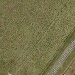
South of Tucson, Arizona (31°38.097'N 111°03.797'W) I found this lovely aerial image. Visualized from an elevation of about a kilometer and a half, it shows a hill just west of I-19 covered in freshly-sprouted grass. Except, there's this strange pattern of evenly-spaced polka-dots:
What could account for the speckles? Alien crop-circles? Bizarre gardening accidents?
Why no, those are the nest discs of one of our most conspicuous insects in the Sonoran desert, the red…