seismicity
Well, after lamenting the slow volcano news, things are beginning to pick up again. Beyond the news of a potential increase in activity at Anak Krakatau, there are a few other newsworthy bits that have come up:
Mt. Kerinci in Indonesia
Mt. Kerinci in Indonesia is showing signs of eruption. The volcano is the highest mountain on the island of Sumatra, reaching 3,800 m / 12,400 feet and last erupted in March 2008. Its volcanic activity is marked by small (VEI 2) explosions of ash and tephra. Currently, the volcano is experiencing increased tremors and minor explosions that rained ash on a tea…
Busy day so I probably won't get to update much as we're busy hosting Dr. Charlie Bacon, geologist for the USGS, here at UC Davis today. Dr. Bacon has written some seminal papers in his career and is probably the foremost authority of the evolution of Crater Lake/Mt. Mazama (speaking of which, >a new geologic map for the Park was recently released) and the caldera-forming eruption. He's also a really nice guy.
If you want to read some of his papers, you might try these:
Bacon, C.R., Implications of silicic vent patterns for the presence of large crustal magma chambers, in: D.P. Hill, R.A…
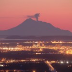
Redoubt from Ninilchik, AK. Image courtesy of Calvin Hall.
It has been a few days since we've talked about Redoubt. Well, it might be because the volcano has settled down for the past week, to the point that AVO put the volcano back to Orange/Watch status last week and hasn't had to go back to Red/Warning since. This is not to say the Redoubt is quiet, on the contrary, there is still elevated seismicity, an almost-constant steam/ash plume up to 15,000 feet / 5,000 meters and most importantly, the new dome (below) is still growing near the summit. The system has been actively degassing carbon…
Fernandina, Ecuador
Fernandina erupting in 2009.
UPDATE 4/13/09 at 12PM: The NASA Earth Observatory has posted a nice MODIS image showing the plume from the Fernandina eruption drifting out over the Pacific.
We have a few more details on the ongoing eruption at Fernandina in the Galapagos Islands. Officials from the Parque Nacional Galápagos (PNG) flew over the island (in spanish) and saw the eruption is coming from a several-kilometer-long fissure vent that flows towards the sea, dividing into multiple flows and then coalescing when it reaches the sea. There is also a lot of vapor being…
Chaiten erupting on January 19, 2009. Image courtesy of the NASA Earth Observatory.
It is hard to believe that we are less than one month away from one-year anniversary of the beginning of the eruption at Chaiten (and with it, the one-year anniversary of this blog!) The volcano in southern Chile is still erupting away, creating at least 2 dome complexes within the older caldera. These domes have been experiencing periodic collapses, creating block & ash flows, some of which have made it out of the caldera and down close to the ghost town of Chaiten. Along with the block & ash flows,…
Image courtesy of Calvin Hall. Taken 3/28/2009 during an eruption at 10:59 AM3:28 PM.
UPDATE 4/2/2009 at 11 AM Pacific: I'm moving this up from the comments, but Eruptions reader Doug Cole pointed out (and I have no idea how I missed this) that Redoubt has a new webcam! This one is at the DFR seismic station, ~8 miles / 12 km northeast of the volcano. Great views on it today showing the extent of the ash around Redoubt and the steam/ash plume. This view will also be excellent if we get any dome collapse pyroclastic flows (see below).
After a week of explosions and ash fall, Redoubt seems to…
For those of you looking for real volcanic eruption news (no, there was no "Yellowstone eruption"), here is this week's SI/USGS Volcano Activity Report.
And speaking of April Fools Jokes, this is by far my favorite (mostly by its combination of volcanoes and baseball. How could you go wrong with two of my favorite things - hat tip to Fletcher for finding the article).
Highlights (beyond Redoubt) include:
Earthquakes, tremors and steam at El Reventador in Ecuador
12,000-15,000 foot (4-5 km) steam/ash plumes were spotted at Colima, the Mexican volcano.
A shockwave was felt 10 km away from…
Image courtesy of the Southern California Earthquake Center
I have to admit, I've only been perpherially following the earthquake swarm currently going on in Southern California, near the end of one of the strands of the San Andreas fault out below the Salton Sea (see the bottom of the map above). The "Bombay Beach" swarm (as I'll call it ... beats me what most people are calling it) is being closely monitored by the USGS. However, from what I had heard from a friend of mine with a more structure/tectonics background, looked like tectonic quakes with "beachball focal mechanism solutions"…
Image courtesy of AVO/USGS by Tricia Joy Sadler. Taken 3/28/2009 at 3:29 PM
Redoubt did not stray from its pattern of explosive eruptions producing >20,000 foot / 10,000 meter ash columns over the weekend. However, what did change was the wind, and because of that, Anchorage began to feel the effects of the volcano. Ash prompted the closure of Ted Stevens International Airport in Anchorage for 22 hours on Saturday and Sunday. The airports near Redoubt are still experiencing delays and closure due to ash - remember, remobilized ash can be a problem as well, but many have reopened after ash…
Image courtesy of AVO/USGS by Ron Beck. Shows an ash plume from Redoubt (tan) on March 26 from a Landsat 5 satellite.
I'll be "off the grid" for the weekend at a wedding, so I thought I'd leave this open for any Redoubt news Eruptions readers hear over the weekend. Feel free to leave comments about the developments up in Alaska.
Currently, AVO reports that seismicity is lower since the eruptions this morning. They indicate that eruptions will likely occur without warning from here on in.
There are also some new articles on how the eruption is affecting air travel, including cancellations of…
Image courtesy of AVO/USGS by Game McGimsey
Following the provided script, Redoubt erupted again last night, producing a 32,000 foot / 10,000 meter ash column that prompted a new ash fall warning for the Kenai Peninsula area. Thus far, though, there have been few reports of major damage being caused by the ash fall. Alaska Air has yet to resume flights to Anchorage due to the ash, but will be reassessing as the day goes on. Since then, the seismicity has settled and we can wait for the next explosion. 2 PM Alaska time? Sounds good to me.
I want to point everyone to the great video montage…
Image courtesy of AVO/USGS. Taken by Cyrus Read
Based on the current levels of seismicity over the past 36 hours, AVO has returned Redoubt to Orange/Watch status from Red/Warning. This doesn't mean that the eruption is over, just that things have settled down a bit. Flights to and from Anchorage have resumed as well. You can read the full statement here, but the take-home messages are:
AVO expects this to be like the 1989-1990 dome-building eruptions, although no new dome magma has been seen yet (mostly thanks to poor weather).
Dome collapse will likely generate pyroclastic flows with…
Redoubt seems to be setting its pattern for this part of the new eruptive period. There was another small explosion this morning that produced at 15,000 foot / 5,000 meter ash column that moved to the NNW. The seismicity has settled down since the early morning eruption today (3/25) as well.
These types of explosions producing plinian and subplinian eruption clouds that will likely lead to dome building - the same pattern seen at Mt. Saint Helens in 2004-2008 and the previous Redoubt eruptions in 1989-1990. These explosions, producing ash columns that reach tens of thousands feet, will likely…
Image courtesy of AVO/USGS
AVO has posted a series of images taken around Redoubt and around the Cook Inlet since the new eruptions started the night of March 22nd. You can begin to see the extent of the ash fall, what the explosions have done to the Drift Glacier and the new deposits in the Drift River valley. Most of the images show a lot of meltwater mudflows and tephra deposits on the slopes of the volcano. They've also added images from satellite and radar sources that show the initial dispersal of ash from the eruptions throughout the area north of Redoubt.
Eruptions reader Akira…
The Hut webcam at Redoubt that has a great view of the hydrothermal vents near the 1989-90 domes - and the area where the current eruption is likely to be sourced - is back online. So far, we can see what looks like lahar deposits on the lower left-hand flanks of the volcano in the stream channels (likely formed by the melting of the Drift Glacier) and ash deposits all over the snow. Also, depending on the light and clouds, you can definitely see an ash column coming from the volcano.
Also, AVO is reporting that at 7:41 PM (Alaska time), a new ash column was spotted on radar reaching 60,000…
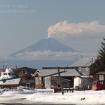
Redoubt on 3/15/2009, from Eagle River overlooking Anchorage. Photo courtesy of Calvin Hall
I'm breaking this out of the comments of the "Redoubt Erupts!" post just to keep things up-to-date.
As of now, we know:
At least 5 explosions have occurred as part of the eruption
Ash has drifted to the NNE and W - both as seen on radar and as reports of ash falling in Skwentna and the Chuitna area - and so far missing populated areas (see above)
The ash cloud is believe to have reached as high as 50,000 feet/15,000 meters - prompting an aviation warning/restrictions and cancellation of flights out…
Seismicity has increased dramatically at Redoubt in Alaska over the last 24 hours, so AVO has put the volcano back on Orange/ Watch status. They say the tremors being felt now could be signs to an impending eruption (days to weeks), especially after the other events of the past week. Stay tuned! (Pardon the briefness, I'm posting from my iPod.)
Now that people have been able to get a better look at the are about Hunga Tonga Hunga Ha'apai, we've been able to get a better idea of what sort of eruption occurred. The explosions and ash/tephra from the eruption have all but wiped out life on Hunga Ha'aapai, as the island contains one of the vents, while the other is only 100 meter off shore of the island - although the tephra erupted so far have joined the new vent and the island. You can clearly see ash mixing with the water around the island and the island itself has been blackened by the coating of ash. This is a classic volcanic…
This falls under the category of "when it rains, it pours". A M7.9 earthquake struck today in the Tongan arc. It doesn't appear to be related to the Hunga Tonga Hunga Ha'apai eruption as it occurred a few hundred kilometers to the SSE of the volcano (remember folks, correlation does not mean causation). The earthquake looks like it was relatively shallow in the crust - ~10 km. All these events will definitely make life even more complicated for the people on Nuku'alofa (Tongatapu), but no word of damage/effects on the Tongan island. A tsunami advisory was also issued for Hawai'i and other…
Mixing volcanoes and oceans seem to always produce exciting results. Whether it is something as simple as the ocean entry of a lava to something as impressive as a new island emerging, formed by volcanic eruption. Back in the 1960s, a previous unknown undersea volcano off the coast of Iceland erupted to form the island of Surtsey. The signs of the impending eruption were captured from start to finish, with Icelandic fisherman noticing "boiling seas", then steam explosions, then ash eruptions and finally volcanic tephra that formed the island itself. This was followed by lava flows and…