Stratovolcano
The NASA Earth Observatory has been dazzling us with images from the Eyjafjallajökull eruption for months - but they have been dazzling us with volcanoes images for years! Here are two more images for those of you who love seeing volcanoes from above:
Cleveland, Alaska
As I mentioned earlier this week, Cleveland volcano likely had a small eruption over the weekend producing a small ash cloud. Cleveland is already known as an extremely picturesque volcano, both from the ground for its highly conical shape - a textbook andesitic stratocone - and from space. This new June 1 image is from almost…
The first Mystery Volcano Photo (MVP, for short) seem to go well and indeed, the volcano in question was Concepcion in Nicaragua. Congratulations to volcanista for nailing it on the first try. I'll have to keep a tally of the winners for each MVP to name a, well, MVP MVP. So far, the scoresheet looks like that.
Volcanista - 1
All the rest of yous - 0
I think we know who has the upper hand.
Volcan Concepcion on Isla Omtepe in Nicaragua.
Anyway, Concepcion! The volcano is a stratovolcano on the island of Ometepe in Lake Nicaragua, which it shares with Madera, another active stratocone. It is…
San Cristobal in Nicaragua
I don't have much in the way of details, but the Associated Press is reporting that San Cristobal in Nicaragua has erupted this evening. The volcano reportedly experienced an explosive eruption and that nearby villages (how nearby is unclear) have received ash fall from the eruption. If it is any indication, government officials did issue a warning to 25 districts around the volcano and so far no casualties have been reported.
UPDATE 8:30 AM (EDT) 9/7/2009: A few more details have come out about the eruption. The ash plume reached ~8,000 m / 26,000 feet, although…
The next up in my Volcano Profiles Series, is one of the most remote volcanoes on the planet, yet also one of the more closely studied and monitored (albeit from afar). Joining Vesuvius, Hood and Rabaul is Mt. Erebus, an active volcano on Ross Island in Antarctica and it definitely has some unique features.
VOLCANO PROFILE: MT. EREBUS
Mt. Erebus in Antarctica with a local resident in the foreground.
Location: Antarctica* (technically, it is on the part of Antarctica claimed by New Zealand, but the Antarctic Treaty System more or less makes the continent an international zone.)
Height: 3,794…
Shishaldin volcano in Alaska.
Yesterday I mentioned in the SI/USGS Weekly Report update that things appear to be afoot at Shishaldin in the Aleutians. Well, I checked the Shishaldin webicorder today and indeed, [SPECULATION] something seems suspect. Now, the increasing signal might be wholly unrelated to any magmatic activity, but it is interesting to see an increase in the seismicity after the increase in the intensity of thermal anomaly at the summit crater.
AVO's latest statement (from yesterday) seems to think that nothing too much is up:
Cloudy conditions prevented views of Shishaldin…
Chaiten in Chile erupting in January 2009. Even after over a year of activity, Eruptions readers are still captivated by the volcano.
Thanks for sending me your questions about volcanoes and volcanism. I'll try to tackle some hear - but as always, keep the questions coming! Send them to
For those of you who have submitted a question but don't see the answer here, do not fret. Likely it just means that I needed to do a little more research into the question and will get to it in a later mailbag!
So, without further ado ...
Mark M.: Here in the Appalachians we have very dense crystalline rock…
Turrialba volcano in Costa Rica.
Turrialba, one of Costa Rica's active volcanoes, is apparently showing signs of life according to a brief report by Teletica 7 (in spanish). There is increased seismic activity and elevated gas emissions at the volcano that last erupted in 2007* and 1866 prior to that. The fumarolic activity at the summit crater is not a new occurrence, however the report implies that it has gotten more intense as the volcano has experienced increasing seismicity since early May. The Volcanism Blog does have an excellent summary of the rumblings at Turrialba since earlier in…
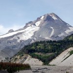
Back in the days when Eruptions was on Wordpress, I held a vote about what volcano should be the next to be profiled on this blog. The winner was Mt. Hood in Oregon, and after much waiting, the profile is here. I will actually be out of town until Monday doing some house shopping in this little town. Enjoy this look at one of the most picturesque (and hazardous - #4 in fact) volcanoes in the lower 48 states.
VOLCANO PROFILE: MT. HOOD
Mt. Hood, Oregon in August 2008 taken by Erik Klemetti.
Location: Oregon, U.S.A.
Height: 3,426 m / 11,240 ft
Geophysical location: Along the Cascade arc where…

Mt. Baker in Washington. Image taken by John Scurlock.
Eruptions reader Robert Somerville brought to my attention the Mount Baker Volcano Research Center, a "clearinghouse for research on Mt. Baker" in Washington state. The center is a non-profit organization that is affiliated with the Geology Department at Western Washington University - and from the looks of the website, they've already done a great job in compiling a lot of information about Mt. Baker, including an excellent eruptive history of the volcano. Mt. Baker is one of the most active Cascade volcanoes, with active fumarolic…
Well, after lamenting the slow volcano news, things are beginning to pick up again. Beyond the news of a potential increase in activity at Anak Krakatau, there are a few other newsworthy bits that have come up:
Mt. Kerinci in Indonesia
Mt. Kerinci in Indonesia is showing signs of eruption. The volcano is the highest mountain on the island of Sumatra, reaching 3,800 m / 12,400 feet and last erupted in March 2008. Its volcanic activity is marked by small (VEI 2) explosions of ash and tephra. Currently, the volcano is experiencing increased tremors and minor explosions that rained ash on a tea…
Image courtesy of KVERT, taken by L. Kotenko on Marhc 18, 2009.
To me, one volcanic arc about which I wish I knew more is the Kuril-Kamchatka arc. I'm well aware of how active it is, with giants composite volcanoes like Bezymianny, Koryak, Klyuchevskoi and many, many others. This arc of volcanoes, although in a sparsely populated part of the world, is important to monitor due to its proximity of air travel lanes to Asia. So, any time I find out a volcano in this area - usually one that I was previously unfamiliar - erupted, I am excited.
Today's example: Ebeko. Never heard of it. Yet, it is…
Image courtesy of AVO/USGS taken by Kristi Wallace showing the eruption plume on March 31, 2009.
Today's update will be relatively brief: AVO has returned Redoubt to Orange/Watch status after this weekend's eruptions. The new dome continues to grow and this is accompanied by the usual volcanic seismicity associated with dome construction. We should expect to see the status fluctuate from Orange to Red as the eruption waxes and wanes - and likely get little to no warning of the next big explosive event.
The eruptions of Redoubt has forced Chevron to halt activity for all its Cook Inlet oil…
Popocatépetl from the ISS on January 23, 2001
It might be (and is likely) just normal behavior for Popocatépetl in Mexico, but the volcano produced six plumes over the last 24 hours, according to a report out of Mexico City (in spanish). Officials from El Centro Nacional de Prevención de Desastres (The National Center for the Prevention of Disasters - Cenapred) say that the plumes appear to be mostly water vapor and other volcanic gases, but remind people living near the volcano to be vigilant.
Popocatépetl is only 70 km from Mexico City, so any major eruption from the volcano could…
Image courtesy of AVO/USGS by Cindy Koplin showing the ash fall in Homer, AK on 4/4/09
Not much new to report about the eruption at Redoubt beyond the fact that it continues. AVO has kept the warning level at Red/Warning after briefly dropping it to Orange/Watch on Friday night. The 15,000 foot / 5 km-tall plume on Sunday was mostly water and volcanic gases. Eagle-eyed observers also noticed a plume on the lower flanks on the north side of the volcano that is believed to be steam generated by block & ash flows interacting with snow or water. These flow block & ash flows are coming…
Llaima erupting in April 2009.
Just a quick note about the eruption currently ongoing at Llaima in Chile. The volcano continues to explosively (and effusively) erupt, sending ash ~22,000 feet / 7,000 meters into the air. This eruption has produced 37 hours of intense eruption (in spanish) so far and the ash from the eruption is drifting into Argentina, almost 100 km to the SE of the volcano. More evacuations are being called for by ONEMI and so far 71 people have left the vicinity of the volcano due to fears of lahars and significant ash fall (In spanish, but it does provide video of the…
Today looks to be a doubleheader of volcano news:
Redoubt
Image courtesy of AVO/USGS, taken by Rick Wessels. An infrared image of the north slope of Redoubt showing the hot, new dome material and hot block & ash flows confined to the valley.
At 11:30 AM yesterday, AVO put Redoubt back to Orange/Watch alert status after the volcano seem to settle down to small steam/ash plumes. Less than 12 hours later (at ~6:30 AM Alaska time), the volcano produced another large explosive eruption, sending an ash column up ~50,000 feet / 15 km and producing what seems to be a significant lahar that…
Image courtesy of USGS/CVO, taken March 8, 2005 from the Cascades Volcano Observatory, Vancouver, WA
For those of you looking for something to relax with and read this weekend, you could wander over to the USGS website and download yourself a copy (for free and legally) of "A Volcano Rekindled: the Renewed Eruption of Mount St. Helens, 2004-2006" (USGS Professional Paper 1750). The report comes in at a mere 872 pages (that's 697 MB download for the whole report), but you can download the pieces that interest you most as well instead of the whole shebang.
Now, I haven't read the whole thing,…
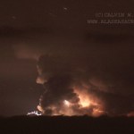
Photo courtesy of Calvin Hall. Taken from March 28, 2009, 50 miles from Redoubt.
Redoubt continues to huff and puff, with an almost constant ash plume of ~15,000 feet / 5,000 meters. This after ~4 PM (Alaska Time), an explosion produced a 25,000 foot / 8,000 meter ash column that disrupted flights in and out of Anchorage again. Also, the air in the Kenai Peninsula area is beginning to feel the effects of the eruption, as AVO notes:
Satellite images from this morning show a broad layer of volcanic haze extending east of the volcano over the Kenai Peninsula, the Anchorage Bowl, and the…
Image courtesy of AVO/USGS by Tricia Joy Sadler. Taken 3/28/2009 at 3:29 PM
Redoubt did not stray from its pattern of explosive eruptions producing >20,000 foot / 10,000 meter ash columns over the weekend. However, what did change was the wind, and because of that, Anchorage began to feel the effects of the volcano. Ash prompted the closure of Ted Stevens International Airport in Anchorage for 22 hours on Saturday and Sunday. The airports near Redoubt are still experiencing delays and closure due to ash - remember, remobilized ash can be a problem as well, but many have reopened after ash…
Image courtesy of AVO/USGS by Ron Beck. Shows an ash plume from Redoubt (tan) on March 26 from a Landsat 5 satellite.
I'll be "off the grid" for the weekend at a wedding, so I thought I'd leave this open for any Redoubt news Eruptions readers hear over the weekend. Feel free to leave comments about the developments up in Alaska.
Currently, AVO reports that seismicity is lower since the eruptions this morning. They indicate that eruptions will likely occur without warning from here on in.
There are also some new articles on how the eruption is affecting air travel, including cancellations of…