
tags: environment, commercial fishing industry, bottom trawling, orange roughy, Chilean sea bass, seafood
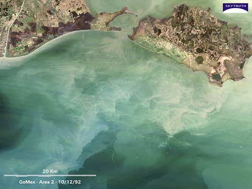
Landsat satellite image, Gulf of Mexico (mouth of Vermillion Bay, Louisiana), taken on 10/12/92. Note the abundant narrow sediment trails, most in shallow water (20m), possibly caused by trawling.
Image: SkyTruth [larger view].
Ain't technology grand? Thanks to Landsat satellite images, which are available on the internet, the ordinary citizen can now see what is happening to our planet -- but sadly, much of it is not good. For example, the above image of the Gulf of Mexico was taken by a Landsat satellite in 1992. The cloudy water that you see is the direct result of commercial bottom trawlers dragging large, heavy nets across the seafloor, denuding it of all life in their quest for a few marketable fish and shrimps. Unfortunately, most bottom trawlers destroy as much as 20 pounds of "bycatch" -- unmarketable corals, sponges, fishes and other animals -- for every pound of commerically valuable "seafood" that they retrieve, while they leave behind huge, choking clouds of mud and sediment that take weeks or longer to settle.
"Bottom trawling repeatedly plows up the seafloor over large areas of the ocean" said John Amos, president of SkyTruth in Shepherdstown, West Virginia. Amos presided over a session at a recent symposium organized by the Marine Conservation Biology Institute.
"Until recently, the impact was basically hidden from view," he continued. "But new tools -- especially Internet-based image sites, like Google Earth -- allow everyone to see for themselves what's happening. In shallow waters with muddy bottoms, trawlers leave long, persistent trails of sediment in their wake."
But the above image reveals only a small part of the problem because most bottom trawling occurs throughout the world's seas in deeper waters than those found in the Gulf of Mexico. In deeper waters, the resulting clouds of silt are invisible to satellites.
"Most .. trawling happens in deep waters, out of sight. But now we can more clearly envision what trawling impacts down there by looking at the sediment plumes that are shallow enough for us to see from satellites," said Les Watling, professor of zoology at the University of Hawaii-Manoa.
In addition to devastating vast areas of the seabed and making them uninhabitable for many years or decades to come, the clouds of sediment are carried by currents into distant waters where they block sunlight and choke sponges, corals and other animals that are the foundation for many marine ecosystems.
"Seafloor animals such as glass sponges are particularly vulnerable to bottom trawling," said Susanna Fuller, PhD candidate in biology at Dalhousie University, Halifax Nova Scotia.
Unfortunately, bottom trawling is a widespread commercial fishing practice.
"Ten years ago, Elliott Norse and I calculated that, each year, worldwide, bottom trawlers drag an area equivalent to twice the lower 48 states," Dr. Watling pointed out. Norse is the president of Marine Conservation Biology Institute in Bellevue, Washington.
Bottom trawling is the primary method whereby commercially valuable deep water fishes, such as the endangered orange roughy, Hoplostethus atlanticus, and Chilean sea bass (Patagonian toothfish), Dissostichus eleginoides, along with a variety of deep water shrimps, are collected for market. Most of these fishes are served at upscale restaurants.
What can you do to reduce this enviromental destruction? Until the industrial fishing industry proves that they are acting in a more environmentally responsible manner, you can boycott eating orange roughy, Chilean sea bass (Patagonian toothfish), and all shrimps. (Keep in mind that those shrimp species that are not caught by trawling are usually farmed in shallow coastal mangroves, which also leads to tremendous, and possibly irreversible, environmental damages).
Fortunately, politicians and lawmakers have been listening to scientists' warnings, at least some of the time. For example, in 2005, trawling was banned in the Mediterranean Sea below depths of 1,000 meters, and the deep sea areas off the coasts of Alaska were closed to bottom trawling. In 2006, the South Pacific nations stopped bottom trawling in an area that covers approximately 14 percent of the Earth's surface. Further, the UN General Assembly is now deliberating about a trawling moratorium on the high seas, which cover 45 percent of the Earth's surface. Let's hope they consider the scientific data to arrive at the correct decision.
Sources
SkyTruth (image).
EurekaAlert (quotes).
I assume "abundant narrow sediment trails" refers to the faint meandering lines. Could those be disturbed areas on the bottom rather than trails of sediment-filled water? The linear features going from upper left to lower right look like imaging artifacts.
I can't believe I'm having to explain easy Reddiquette to you again.
A submission that features a picture and a submission that is a picture are two different things. Your tag was misleading.
mark p: the faint meandering lines are the actual trawl trails, the clouds are the disturbed sediment that is floating all over creation.
aerik; geez, chill out. no one has to read the words that accompany the picture. it's not like i am posting a thumbnail at the bottom of a 2500 word essay full of big scary words or anything.
anyway, JUST to make you happy, i went and posted JUST a pic, so now you owe me a happy comment or a smiley face or something.
While I'm thinking of it, there is another good reason to avoid certain seafood. One of the Atlanta TV stations did a report on imported seafood. They talked to a state test lab official in Alabama (can you believe they actually have something like that?), who reported on the terrible conditions of some foreign farm-raised seafood and all the various types of chemicals they contain. The reporter asked the lab guy what he does when he orders seafood in a restaurant. The lab guy said he never does that.