aviation
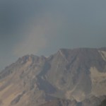
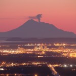
Sarychev Peak in the Kuril Islands in 2007, the source of the large ash column currently disrupting transpacific air traffic.
It seems that the eruption at Sarychev Peak in the Kuril Islands of Russia might be a lot bigger than it first seemed. I've gotten a couple reports of flights to Tokyo from North America being diverted or delayed due to the ash threat, including All Nippon Air Flight 1 (Washington DC to Tokyo) and Continental Flight 7 (Houston to Tokyo, diverted to Anchorage). The NASA Earth Observatory has some great new images of the eruption taken today from the MODIS on the Aqua…
Sarychev Peak in Russia erupting on June 14, 2009. Image courtesy of the NASA Earth Observatory.
The transpacific air routes over the Aleutians, the Kamchatka Peninsula and the Kuril Islands are a prime location for the threat of ash to commercial aviation. Many of these volcanoes, especially on the western side of the Pacific Ocean are not closely monitoring and sometimes only remote sensing techniques can keep track of the activity.
Case in point is the current eruption at Sarychev Peak in the Kuril Islands. The volcano is on one of the southern-most Kuril Islands (Ostrov Matua) in Russia…
Chaiten erupting in May 2008. Image courtesy of ONEMI.
Speaking of anniversaries, this weekend is the one-year mark for the Chaiten eruption (in spanish) in Chile, the first eruption at the volcano in ~9,000 years. Yes, indeed, the rhyolite eruption that caught most everyone by surprise is still going strong one year later, with two domes growing within the caldera (in spanish). The eruption produced some of the most impressive and sustained ash columns in years (see below) - climbing to 16 km/9 mi, abundant lahars and pyroclastic flows from the emergence and growth/collapse of the domes and…
Descabezado Grande, Chile showing increased fumarolic activity in 2009.
Well, if they didn't have enough already between Llaima and Chaiten, another volcano in southern Chile has started erupting. Descabezado Grande (roughly translated: "The Big Beheaded One") has erupted or is showing of eruption (in spanish and NOTE that the picture in the article is of Llaima, NOT, I repeat, NOT Descabezado Grande ... grrr) but details are scant on the actual activity. However, scientists from the SERNAGEOMIN are headed to the area to evaluate the volcano - hopefully the reports are accurate. So far,…
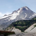
Back in the days when Eruptions was on Wordpress, I held a vote about what volcano should be the next to be profiled on this blog. The winner was Mt. Hood in Oregon, and after much waiting, the profile is here. I will actually be out of town until Monday doing some house shopping in this little town. Enjoy this look at one of the most picturesque (and hazardous - #4 in fact) volcanoes in the lower 48 states.
VOLCANO PROFILE: MT. HOOD
Mt. Hood, Oregon in August 2008 taken by Erik Klemetti.
Location: Oregon, U.S.A.
Height: 3,426 m / 11,240 ft
Geophysical location: Along the Cascade arc where…
Redoubt from Ninilchik, AK. Image courtesy of Calvin Hall.
It has been a few days since we've talked about Redoubt. Well, it might be because the volcano has settled down for the past week, to the point that AVO put the volcano back to Orange/Watch status last week and hasn't had to go back to Red/Warning since. This is not to say the Redoubt is quiet, on the contrary, there is still elevated seismicity, an almost-constant steam/ash plume up to 15,000 feet / 5,000 meters and most importantly, the new dome (below) is still growing near the summit. The system has been actively degassing carbon…
Image courtesy of KVERT, taken by L. Kotenko on Marhc 18, 2009.
To me, one volcanic arc about which I wish I knew more is the Kuril-Kamchatka arc. I'm well aware of how active it is, with giants composite volcanoes like Bezymianny, Koryak, Klyuchevskoi and many, many others. This arc of volcanoes, although in a sparsely populated part of the world, is important to monitor due to its proximity of air travel lanes to Asia. So, any time I find out a volcano in this area - usually one that I was previously unfamiliar - erupted, I am excited.
Today's example: Ebeko. Never heard of it. Yet, it is…
Llaima erupting at night in April 2009.
Brief update for those of you following the somewhat spectacular eruption (above and below) going on at Llaima in Chile. The latest reports indicate the eruption is waning (in spanish) with less ash and explosions (in spanish) being produced. However, ONEMI, the Chilean Emergency Office, continues to keep the area on alert. So far, at least 81 people have been evacuated (in spanish) during the eruptions that gained strength over the weekend and flights between Buenos Aires and Neuquén were suspended due to the ash.
It is interesting to note the…
Hunga Tonga Hunga Ha'apai, taken in late March 2009
Redoubt did the tried-and-true American trick of shoving news of volcanoes in other parts of the world off the news pages, but shockingly, these international volcanoes continued to erupt. Remember that volcano in Tonga? Hunga Tonga Hunga Ha'aapi? Still erupting, weeks after the volcano was first spotted. The volcano is still disrupting air traffic in and out of Tonga, which is now even affecting the economy of the islands. Now, the problem is that tourists are creeping ever closer to the emerging volcanic island. The thing about visiting…
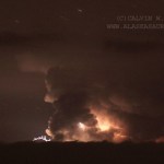
Photo courtesy of Calvin Hall. Taken from March 28, 2009, 50 miles from Redoubt.
Redoubt continues to huff and puff, with an almost constant ash plume of ~15,000 feet / 5,000 meters. This after ~4 PM (Alaska Time), an explosion produced a 25,000 foot / 8,000 meter ash column that disrupted flights in and out of Anchorage again. Also, the air in the Kenai Peninsula area is beginning to feel the effects of the eruption, as AVO notes:
Satellite images from this morning show a broad layer of volcanic haze extending east of the volcano over the Kenai Peninsula, the Anchorage Bowl, and the…
Image courtesy of AVO/USGS by Tricia Joy Sadler. Taken 3/28/2009 at 3:29 PM
Redoubt did not stray from its pattern of explosive eruptions producing >20,000 foot / 10,000 meter ash columns over the weekend. However, what did change was the wind, and because of that, Anchorage began to feel the effects of the volcano. Ash prompted the closure of Ted Stevens International Airport in Anchorage for 22 hours on Saturday and Sunday. The airports near Redoubt are still experiencing delays and closure due to ash - remember, remobilized ash can be a problem as well, but many have reopened after ash…
Image courtesy of AVO/USGS by Ron Beck. Shows an ash plume from Redoubt (tan) on March 26 from a Landsat 5 satellite.
I'll be "off the grid" for the weekend at a wedding, so I thought I'd leave this open for any Redoubt news Eruptions readers hear over the weekend. Feel free to leave comments about the developments up in Alaska.
Currently, AVO reports that seismicity is lower since the eruptions this morning. They indicate that eruptions will likely occur without warning from here on in.
There are also some new articles on how the eruption is affecting air travel, including cancellations of…
Image courtesy of AVO/USGS by Game McGimsey
Following the provided script, Redoubt erupted again last night, producing a 32,000 foot / 10,000 meter ash column that prompted a new ash fall warning for the Kenai Peninsula area. Thus far, though, there have been few reports of major damage being caused by the ash fall. Alaska Air has yet to resume flights to Anchorage due to the ash, but will be reassessing as the day goes on. Since then, the seismicity has settled and we can wait for the next explosion. 2 PM Alaska time? Sounds good to me.
I want to point everyone to the great video montage…
Image courtesy of AVO/USGS, taken 3/23/09
I don't have many details, but the largest eruption so far in this eruptive stage at Redoubt occurred at 9:24 AM (Alaska Time), producing a 65,000 foot / 20,000 meter ash column! Yes, you read that right, a 20-km ash column! This is by far the largest ash column so far and AVO has returned Redoubt to Red/Warning status after this and a small explosion that occurred 30 minutes before the big one. Depending on the winds at various elevations, this sort of large ash column could threaten to coat Anchorage with ash - check the latest NOAA warnings here…
Image courtesy of AVO/USGS. Taken by Cyrus Read
Based on the current levels of seismicity over the past 36 hours, AVO has returned Redoubt to Orange/Watch status from Red/Warning. This doesn't mean that the eruption is over, just that things have settled down a bit. Flights to and from Anchorage have resumed as well. You can read the full statement here, but the take-home messages are:
AVO expects this to be like the 1989-1990 dome-building eruptions, although no new dome magma has been seen yet (mostly thanks to poor weather).
Dome collapse will likely generate pyroclastic flows with…
Image courtesy of AVO/USGS
AVO has posted a series of images taken around Redoubt and around the Cook Inlet since the new eruptions started the night of March 22nd. You can begin to see the extent of the ash fall, what the explosions have done to the Drift Glacier and the new deposits in the Drift River valley. Most of the images show a lot of meltwater mudflows and tephra deposits on the slopes of the volcano. They've also added images from satellite and radar sources that show the initial dispersal of ash from the eruptions throughout the area north of Redoubt.
Eruptions reader Akira…
The Anchorage Daily News has a report that 16 Alaskan representatives got stuck in Anchorage after the eruption started. They were headed to Juneau to vote on Alaska accepting stimulus money ("volcano monitoring" anyone?), but they were on one of the many flights canceled by Alaska Airlines today due to the ash. ADN also have reports of an "ash out" in the coastal town of Skwentna.
AVO is currently reporting that ash doesn't appear on the current radar maps in the Cook Inlet and there are no reports of new ash fall. This suggests that the ash is either staying below 13,000 feet / 4,000…
Redoubt on 3/15/2009, from Eagle River overlooking Anchorage. Photo courtesy of Calvin Hall
I'm breaking this out of the comments of the "Redoubt Erupts!" post just to keep things up-to-date.
As of now, we know:
At least 5 explosions have occurred as part of the eruption
Ash has drifted to the NNE and W - both as seen on radar and as reports of ash falling in Skwentna and the Chuitna area - and so far missing populated areas (see above)
The ash cloud is believe to have reached as high as 50,000 feet/15,000 meters - prompting an aviation warning/restrictions and cancellation of flights out…
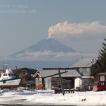
Mt. Redoubt in March 2009, prior to erupting
At ~10:30 PM (Alaskan Time) last night, Mt. Redoubt erupted. AVO and the Anchorage VAAC issued a Red Alert for ash as high as 50,000 feet (15,000 meters) around the volcano. Information is scarce about the exact nature of the ash cloud because of the fact that the volcano erupted at night. The eruption has contained at least 5 large explosion and at least one of the seismometers at the volcano has stopped reported (RSO). An ashfall advisory has been issued by the Weather Service, with ash predicted to fall throughout the Susitna Valley (which…
Now that people have been able to get a better look at the are about Hunga Tonga Hunga Ha'apai, we've been able to get a better idea of what sort of eruption occurred. The explosions and ash/tephra from the eruption have all but wiped out life on Hunga Ha'aapai, as the island contains one of the vents, while the other is only 100 meter off shore of the island - although the tephra erupted so far have joined the new vent and the island. You can clearly see ash mixing with the water around the island and the island itself has been blackened by the coating of ash. This is a classic volcanic…