sulfur dioxide
Some brief notes before I dive headlong into the exciting world of faculty orientation!
A small steam plume coming from Turrialba in Costa Rica. Photo taken in August 2007.
There are some preliminary reports of the state of wildlife (and everything) around Kasatochi Island in the Aleutians from the US F&W and USGS team that headed to check out how the island has recovered since last year's eruption. The shoreline has been radically transformed by the ash and although some seabirds have made attempts to nest in the loose ash, it doesn't seem to have been very successful. However, not…
Does anyone else feel like this has been a rather quiet summer, volcano-wise? Maybe I've been too preoccupied by my move to Ohio, but I feel like beyond a few relatively minor events (Shiveluch comes to mind), the volcano news has been pretty slow compared to the spring of this year. Go figure.
The sulfur dioxide plume from the 2008 eruption of Kasatochi spreading over the northern Pacific Ocean.
Anyway, a few tidbits to tide us over:
Over eighteen years after the eruption, Mt. Pinatubo is still causing fatalities from the copious amounts of tephra deposited during the 1991 event. Five…
The next up in my Volcano Profiles Series, is one of the most remote volcanoes on the planet, yet also one of the more closely studied and monitored (albeit from afar). Joining Vesuvius, Hood and Rabaul is Mt. Erebus, an active volcano on Ross Island in Antarctica and it definitely has some unique features.
VOLCANO PROFILE: MT. EREBUS
Mt. Erebus in Antarctica with a local resident in the foreground.
Location: Antarctica* (technically, it is on the part of Antarctica claimed by New Zealand, but the Antarctic Treaty System more or less makes the continent an international zone.)
Height: 3,794…
Your weekly dose of volcanism from the USGS/Smithsonian Global Volcanism Program.
Highlights (not counting Mayon), include:
The activity at Mando Hararo in Ethiopia appears to be a fissure eruption. Ground observations saw a 4-5 kilometers / ~2.5-3 mile fissure with new predominantly 'a'a lava flows that were 2-3 m thick ... the fissure was lined with scoria ramparts 30-50 m high. They did not see any active lava, though.
As some Eruptions readers have pointed out from the OMI SO2 maps, Sarychev Peak (Russia) is still producing gas-and-steam (with some ash) plumes, mostly drifting off to the…
Two papers submitted, one to go. Keeps you quite busy, let me tell you.
Lava flow from a 2006 eruption on Mayon in the Philippines.
A few bits of news today:
A few more details about the ongoing watch of Mayon in the Philippines . There have been apparently no changes in the shape of the floor of the crater as you might expect if magma was rising underneath. However, there has been an overall inflation of Mayon since the unrest began a few weeks ago. PHIVOLCS will be checking the sulfur dioxide and carbon dioxide output of the volcano soon as well.
Lots of articles this week about the "…
A quick update on the rockfall in the Halema`uma`u (got it right this time!) Crater at Kilauea. Last week a rockfall blocked the vent that had been glowing for most of the year from the lava below, but the debris clogged the vent, producing minor accidental tephra explosion.
Lava in the recently "clogged" Halema`uma`u vent at Kilauea. Taken July 6, 2009, courtesy of HVO.
Well, it didn't take long for lava to retake the "clogged" vent. New video from HVO shows lava bubbling back up through the clogged vent (see the video in the above link). The lava has formed a small lava and even produced…
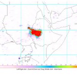
Three days ago, I received an email from Eruptions reader Gijs de Reijke who was curious about something he noticed in the daily OMI SO2 images:
OMI sulfur dioxide map over Ethiopia for June 30, 2009.
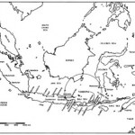
Now, I wasn't quite sure what to make of it other than the fact that there was an awful lot of sulfur dioxide in the vicinity of Addis Ababa, which seemed odd. If we look at a map of the active volcanoes in Ethiopia (below), a majority of the ones we might suspect if the SO2 was volcano are to the north (Erte Ale, Dallafilla), but this patch is smack-dab in the middle of the country, looking…
Flight path for Continental Flight 009 from Newark to Tokyo, diverted back to Newark due to the threat of ash from Sarychev Peak. Image courtesy of Flight Aware.
The eruption at Sarychev Peak is continuing to disrupt all sorts of flights that head towards Asia. There are lots of unhappy travelers who have had to "enjoy" a 12 hour flight that took them from Newark, NJ to ... Newark, NJ (see yesterday's Continental Flight 009 above). There have been a multitude of flights affected by the ash, many reported here on Eruptions by travelers or relatives (keep them coming!) It will be interesting…
Things are busy - both volcanically and personally - so I'm going to just give you some links to a bunch of exciting/interesting/insane news:
West Mata erupting on May 5, 2009 in the Lau Basin.
According to a bunch of news sources, the eruption at Fernandina in the Galapagos is over (in spanish). That being said, the PNG noted that there is still a lot of carbon dioxide and sulfur dioxide being emitted, suggesting there is still a lot of degassing magma beneath the vents - at what depth (and will it erupt) is the question.
There is a lot of speculation that Nyiragongo (DRC) is erupting or…
Has a week gone by already? It is time for another USGS/Smithsonian GVP Weekly Volcano Activity Report.
Highlights (beyond Fernandina, Pagan and Redoubt) include:
A new underwater eruption at NW-Rota 1 in the Mariana Islands.
Increasing seismicity and incandescence from the rhyolite domes forming at Chaiten, Chile.
A spike in sulfur dioxide emissions from Kilauea, Hawai'i to 700 tonnes/day (up from a 2003-07 average of 150 tonnes/day).
4.5-7.5 km / 15-26,000 foot ash columns produced at Shiveluch in Kamchatka from new lava dome.
Continued dome growth and ~6 km / 26,000 foot ash columns from…
Fissure vent eruption from Fernandina in the Galapagos Islands.
In news that comes as a surprise to no one, the current eruption on Fernandina in the Galapagos is having some adverse effect on the wildlife in the Pacific archipelago. Numerous dead fish and sea lions have been seen in the ocean near the actively erupting volcano - now, what exactly is causing the deaths is more speculative. I would imagine with the large plume being produced by the volcano, along with the lava flows reaching the ocean, that volcanic gases and the lava's interaction with the sea water might be the leading…
Tambora, Indonesia
There are big eruptions, then there are big eruptions. On April 10, 1815, Tambora, a volcano in Indonesia, produced one of the largest eruptions in human history. This eruption produced what became known as the "year without a summer" after the volcanic aerosols from the eruption produced some of the coldest summers in many parts of the world. The Tambora eruption in 1815 was a VEI 7, on a scale that goes to, well, 7*, putting it in a class of some of the largest and most violent eruptions imaginable - and I, for one, can hardly imagine what might happen if an eruption of…
Image courtesy of AVO/USGS by Cindy Koplin showing the ash fall in Homer, AK on 4/4/09
Not much new to report about the eruption at Redoubt beyond the fact that it continues. AVO has kept the warning level at Red/Warning after briefly dropping it to Orange/Watch on Friday night. The 15,000 foot / 5 km-tall plume on Sunday was mostly water and volcanic gases. Eagle-eyed observers also noticed a plume on the lower flanks on the north side of the volcano that is believed to be steam generated by block & ash flows interacting with snow or water. These flow block & ash flows are coming…
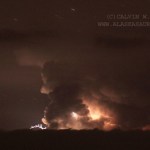
Photo courtesy of Calvin Hall. Taken from March 28, 2009, 50 miles from Redoubt.
Redoubt continues to huff and puff, with an almost constant ash plume of ~15,000 feet / 5,000 meters. This after ~4 PM (Alaska Time), an explosion produced a 25,000 foot / 8,000 meter ash column that disrupted flights in and out of Anchorage again. Also, the air in the Kenai Peninsula area is beginning to feel the effects of the eruption, as AVO notes:
Satellite images from this morning show a broad layer of volcanic haze extending east of the volcano over the Kenai Peninsula, the Anchorage Bowl, and the…
Image courtesy of AVO/USGS by Tricia Joy Sadler. Taken 3/28/2009 at 3:29 PM
Redoubt did not stray from its pattern of explosive eruptions producing >20,000 foot / 10,000 meter ash columns over the weekend. However, what did change was the wind, and because of that, Anchorage began to feel the effects of the volcano. Ash prompted the closure of Ted Stevens International Airport in Anchorage for 22 hours on Saturday and Sunday. The airports near Redoubt are still experiencing delays and closure due to ash - remember, remobilized ash can be a problem as well, but many have reopened after ash…
Photos by Dr. Edward Kohut, all rights reserved, used by permission, 2009
Many times people think that volcanic eruptions affect the economy through the destruction inflicted upon the landscape during an eruption: lahars and pyroclastic flows destroying bridges and homes, ash ruining crops and water, lava flows overunning communities. However, in Hawai'i, a new effect of volcanism has been seen in the agriculture of the state. The volcanic fog - or "vog" as its called - has been causing major problems with farms on the Big Island of Hawai'i. Since the new activity at Halemaumau (see above)…
A week ago, if you asked around, I'm sure most people would have thought Redoubt would have erupted by now considering all the seismicity and melting that was seen at the end of last week. However, volcanology is not an exact science, and here we are continuing to watch Redoubt tease us with signs of pending activity. New holes have appeared in the snow that caps the volcano, the seismicity continues and the volcano is still spewing sulfur dioxide, carbon dioxide and hydrogen sulfide - all signs that magma is intruding the volcanic edifice. However, as on this morning (2/5/2009), the volcano…
I was chatting with a fellow from AVO and he called the simultaneous eruptions of Kasatochi, Cleveland and Okmok a "once in a millennia" event. So, enjoy it!
He also mentioned that the Kasatochi eruption released the most sulfur dioxide into the atmosphere since the 1991 Pinatubo eruption ... but we had an idea of that already.
And who knew that there has been uplift at Uturuncu in Bolivia? I sure didn't, but Steve Sparks does.
Â
More to come later this week when I can go to all the Chaiten posters.
Just to keep everyone on their toes, Soufriere Hills on Montserrat in the West Indies erupted today. The eruption produced a number of explosions and a pyroclastic flow that originated from the west side of the lava dome at the summit of the volcano. However, the most interesting bit comes from the Montserrat Volcano Observatory (MVO) report I received this morning:
"The explosion happened without any warning. There was no precursory seismic activity."
Sounds like it could have been a dome collapse caused by a rapid release of gas/steam? The explosion apparently threw blocks as far as…
Sounds like we're beginning to get a better idea of what is erupting in Ethiopia. Ghezahegn Yirgu, a geologist at Addis Ababa University, reports that Dalla Filla Dalaffilla Volcano is the source of the eruption. Again, the eruption is being characterized as "lava flows" rather than an explosive eruption, which may be surprising considering the amount of volcanic gases being released (see Boris Bechnke's highly useful comment). However, some mostly effusive eruptions have released a lot of volcanic gases in the past - see Laki, Iceland in 1783 - so a preponderance of flows…