Tropical Storm
LATEST UPDATE IS HERE. CLICK HERE FOR LATEST UPDATE.
Update: Wed Mid Day
Matthew weakened, strengthened, strengthening
Matthew has interacted with land masses in Hispaniola and Cuba to the extent that the storm weakened quite a bit, losing its temporary Category 5 status.
But, now Matthew is already showing signs of strengthening, and is likely to grow back to Category 3 or 4 status as it moves over the Bahamas. How bad a hurricane is when it makes contact with land depends in large part on the angle of the attack, and Matthew will likely be affecting several spots in the Bahamas at a…
For the latest post on Hermine GO HERE.
Update Thursday PM
Hermine has grown in strength, and may even make landfall as a Category 2 storm. At least a strong Category 1.
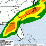
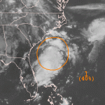
The right front quadrant of the storm is where the main "punch" (of winds) is located. If the storm winds come into an embayment, they can really build up the storm surge. Look at this image:
You can see the right front quadrant of the storm heading right into Apalachee Bay. Barrier islands to the west of the bay's head, and the communities right in the bay, are very much at risk for severe flooding.
Here is a blowup…
But first a word bout Chan-Hom. That typhoon messed with China but not as badly as originally feared, because the storm turned to the east a bit. Now, Chan-Hom is heading for North Korea where it will come ashore as a wet tropical storm. I would not be surprised if more bad stuff happened there than with Chan-Hom's glancing blow over the last 24 hours or so.
Now I'd like to direct your attention the Atlantic Ocean for a moment. Due to vertical wind shear and aridification-induced North African dust, we have been expecting that one effect of climate change would be that most (but not all)…
Maybe yes, maybe no. Good chance, yes.
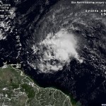
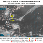
It is too early to call, but the blob I mentioned the other day has turned into a spiral and is starting to get organized. Forecasters at NOAA think there is an 80% chance this low pressure phenomenon will be a tropical storm by the 4th of July. They are also, somewhat vaguely, saying that it will move south, then northward, then northwest, which puts the storm off the coast of the US Mid-Atlantic or Southeast somewhere. Given that the storm is not moving in a consistent direction steered by well defined one directional forces, this should be very…
There is a stormy thing in the Atlantic that may become a Tropical Storm. It is really just a blob right now, but there is a roughly even chance that over the next two to five days it will form a tropical storm.
No matter what, this blob will menace the US east coast, though it is way too early to say if this will be a big deal or not. It is not entirely clear which direction it will be moving in over the medium term. We will be keeping and eye on it.
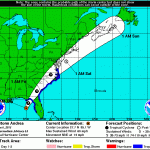
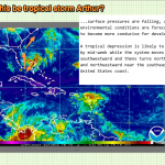
The first named storm of the Atlantic hurricane season has developed. Tropical Storm Andrea formed over the last several hours, and now exhibits winds of 63 knots at 5000 feet, with a surface intensity of about 50 knots, though these winds are only found in the "right hand" side of the storm, now sitting in the northeastern Gulf of Mexico. Most likely, this is all Andrea is going to manage as the storm moves north to make landfall, where it will also interact with upper level winds which will convert the storm to a big rain storm over the next day and a half. However, Andrea will be a very…