USGS
Steaming, gurgling mudpots in the active hydrothermal system of Yellowstone.
For those of you following Yellowstone (I think there might be a few of you), I've plotted up the earthquakes since 1/27 (see below) - and sure enough, although there is a lot of scatter, they are getting shallower - however what this exactly means is unclear. You can see my plots from 1/22-28 here. As many of you have mentioned, a caldera like Yellowstone is a big interconnected system, so a solely tectonic source of this is still possible as the displacement migrates through the fractured caldera rocks.
UPDATED…
First off, I wanted to thank all of the Eruptions readers for making January the most popular month ever on this blog. I suppose I should give an assist to Yellowstone, but really, thanks for coming to the blog, reading the posts and engaging in all the great discussions that go on within its (cyber)walls.
KÄ«lauea's east rift zone eruption site. Image courtesy of the USGS/HVO.
On to some news!
I suppose you've made the big time when you're in the New York Times, and sure enough, the current Yellowstone earthquake swarm is in the Old Grey Lady. Nothing much new to read, but summarizes the…
Some news for the last Friday in January:
Volcanic lightning captured over Redoubt in March 2009.
Tungurahua in Ecuador continues to erupt. Yesterday, the volcano spread ash over much of central Ecuador. Apparently people in Ecuador aren't taking the hazard of ash too seriously, with many ignoring recommendations to wear masks when the ash is falling. Over 50 explosions have been recorded over the last 24 hours at the volcano according to the Ecuadorian Instituto GeofÃsico, most of them small to moderate.
We also have a new USGS/Smithsonian Institute Volcano Activity Report. Much of the "…

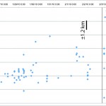
There has been a ... ahem ... healthy discussion of Yellowstone's current earthquake swarm on Eruptions as of late. We've now reached ~1,500 measurable earthquakes over the last 11 days. The latest reports of the continuation of the swarm isn't going to make anyone happy, but still, there are no signs that (a) this is out of the ordinary and (b) indicates magma making its way to the surface. In fact, if you plot the earthquakes since the 22nd of January, the depth appears to getting, well, deeper:
This plot shows the earthquakes listed on the USGS earthquake page since January 22 (oldest to…
Old Faithful geyser at Yellowstone National Park.
A few thoughts about faulting, earthquakes and eruptions:
The earthquakes at Yellowstone have been universally attributed to fault movement rather than magmatic activity by the USGS and the researchers at the University of Utah. This is likely based on the moment solutions for the earthquakes (i.e., the sense of motion on the earthquake - side to side, dilation, etc.) and the fact that there are no directly correlative volcanic/magmatic symptoms to go with them (such as pronounced, short-term bulging, excessive hydrothermal venting, etc.) Now…
Outcrops of Obsidian Butte, California, near the Salton Sea.
A brief update on the two earthquake swarms making news right now:
Yellowstone
The earthquake swarm at Yellowstone is still rumbling along, reaching over 1,000 earthquakes measured over the last week. However, the swarm has begun to die down overnight - with no earthquakes between 10:41 PM (MST) on 1/22 and 6 AM on 1/23. However, although this is a longer, bigger swarm than normal, it still isn't out of the regular rumblings at Yellowstone caldera. The USGS continues to say this swarm is tectonic, rather than magmatic or…
This week's USGS/Smithsonian GVP Volcano Update!
Highlights include:
A volcano I had never heard of in the Kuril islands is showing signs of life: Kharimkotan. Satellite images show a thermal anomaly at the summit of the volcano - its last known eruption was in 1933.
Ash, sulfur dioxide and steam continue to erupt from Nyamuragira in the Congo, although lava flows have abated.
Crater C at Arenal had sporadic strombolian activity - which is par for the course for the Costa Rican volcano.
I must have missed this, but since December 14, the ash erupted at Gaua in Vanuatu has become denser and…
A hot spring in Yellowstone National Park. Image courtesy of the USGS.
Yesterday I left a little teaser about the current earthquake swarm going on at the Yellowstone Caldera. Eruptions readers have come through with even more information on the swarm. Over 250 earthquakes have occurred in the park over the last few days, most between 0.5-3.1 on the Richter Scale - and getting larger each day. The swarm is centered 10 miles northwest of Old Faithful, Wyoming and 9 miles southeast of West Yellowstone. However, before everyone gets too excited, Dr. Robert Smith of University of Utah (the go-to…
The steam plume from Turrialba on December 26, 2009. Image by Eruptions reader Sahrye Cohen.
Turrialba
Costa Rican officials extended the evacuation zone around Turrialba from 3 to 6 km, raising the alert status at the volcano to Yellow. Vanessa Rosales of the National Emergency Commission described the seismicity as "intense but low," but says the country is prepared to deal with the emergency. As always, the news chooses oddly what is the "news" of an event, and many article on Turrialba focus on Costa Rica's coffee - yes, it is safe, so far. A news report from the Tico Times quotes Raul…
Two volcanoes down, two volcanoes up!
Fire fountain on Nyamuragira in the Congo, January 2010.
Down
Mayon
Activity at Mayon has continues to drop - although PHIVOLCS warns that an eruption could happen at any moment and without much warning. About a quarter of the evacuated families have no returned home since PHIVOLCS gave the OK to return home on January 2 - but Philippine officials are still on alert in case evacuations have to be reinstated.
Redoubt
The resurgent Redoubt is no long ... er ... resurging? AVO lowered the alert status to Green - meaning normal/background levels of activity…
A pile of news for the new week!
The glow of new lava flows from Nyamuragira in the Congo, taken from the Virunga Park Headquarters, January 2, 2010.
Mayon
PHIVOLCS may lower the alert status at Mayon to Level 2 after almost a week of lower seismicity and no ash explosions since December 29th. Schools that were being used as evacuation centers were also returned to teachers and students for the start of classes after the Christmas holiday. However, the Albay provincial government is now considering a plan to permanently move everyone who lives within the 6-km danger zone around Mayon, even…
Here it is, my attempt to recap a year's worth of volcanic events. By no means is this supposed to capture every event, but rather the highlight/lowlights and what most captivated me during 2009. I'll be announcing the winner of the 2009 Pliny for Volcanic Event of the Year tomorrow.
Waimangu Geothermal Valley in New Zealand, taken in January 2009 by Erik Klemetti.
January
The year started out with a trip to New Zealand (well, for me at least) and vistas of the Waimangu Valley, formed in the 1886 eruption of Tarawera on the North Island. We were also still thinking about the late 2008…
Not much new to report today, so I'll just add some notes to the two volcanoes in the news right now: Mayon and Redoubt.
Mt. Redoubt in Alaska, taken on September 23, 2009. Image courtesy of AVO/USGS, taken by Game McGimsey.
Mayon:
The volcano continues to show signs that a major eruption is in the works, but nothing new occurred over the last 24 hours. 2 km / ~5,000 foot ash plumes were produced from the new dome/flow complex, causing a potential aviation hazard, and the lava flows continued to be erupted. In evacuation news, animals are now being evacuated from the hazard zone around the…
The most recent image on the AVO website of the dome at Redoubt, taken in November 2009. Image courtesy of AVO/USGS, by Cyrus Read.
Not much information on this, but AVO just raised the alert status at Redoubt in Alaska to Yellow for the first time since late September. A series of small earthquakes were detected near the summit dome starting at 10 A.M. today, prompting the change of status.
The link to the complete text of the change in status doesn't seem to work on the AVO site, so here it is:
2009-12-28 09:53:11 - VAN/VONA
AVO is raising the Aviation Color Code to YELLOW and the Volcano…
Before it gets lost in the mists of time/finals, here is the weekly volcano report brought to us by the USGS and the Smithsonian Global Volcanism Program.
Highlights (not including Mayon, Soufriere Hills or Piton de La Fournaise):
Fuego in Guatemala produced ash plumes that reached 4.1-4.7 km / 13,500-15,400 ft along with avalanches of volcaniclastic debris.
Also in Guatemala, lava flows erupted from Pacaya, traveling hundreds of meters from the main vent area.
Manam in PNG produced an 3 km / 10,000 foot ash plume as part of its renewed activity this year.
The lava dome on Nevado del Huila…
A new Weekly Volcano Report from the Smithsonian GVP/USGS ... enjoy!
Highlights include:
There has been a number of reports of new activity at Llaima in Chile (hat tip to Eruptions reader Manuel Humeres for bringing them to us). Most of the current activity is steam-and-gas plumes along with long-period seismicity, suggesting we could be headed towards a new eruption.
Lava flows continue to erupt from Kliuchevskoi in Kamchatka, along with strombolian activity throwing ejecta up to 300 m / ~1000 feet above the crater.
Rabaul is busy shaking windows 20 km / 12 miles from the Tavurvur crater,…
Some news for today:
Yellowstone National Park, USA.
Another fine example of media headline versus actual research, an article in the Jackson Hole Daily about a new study by Dr. Robert Smith and others on the Yellowstone plume was titled "Park's giant magma plume eating up mountains". Yikes! Well, the actual study published recently in the Journal of Volcanology and Geothermal Research is more about the geophysical parameters of the Yellowstone plume - a plume that might reach as far as 500 km below the caldera itself. As for the mountain eating part, I think they were trying to get at the…
We get a new update from the Smithsonian/USGS Global Volcanism Program ...
Highlights (not counting Soufriere Hills or Gaua) include:
The Weekly Report mentions the mystery eruption/noneruption of Karkar in PNG. Specifically, they report:
The report also stated that ash had merged with a thunderstorm cloud and had become unidentifiable.
Two ash plumes (11/25, 26) that reached at least 9.1 km / 30,000 feet were reported by the Darwin VAAC ... but as we know, it is far from clear that anything actually happened at Karkar last week.
Activity has quieted significantly at Chaiten in Chile, with…
The latest news from the USGS/Smithsonian Global Volcanism Program Weekly Volcano Report ...
Highlights (not including Mayon) include:
Strombolian eruptions and small pyroclastic falls at Arenal in Costa Rica.
3 km / 10 000 foot ash plume from Bagana on Bougainville Island in Papua New Guinea.
Rumbling noises, ~4.5 km / 14 000 foot ash plumes and incandescence were all reported coming from Fuego in Guatemala.
Steam-and-ash from Popocatepetl near Mexico City reached 7.4 km / 24 300 feet.
Satellite images of Shiveluch revealed a large thermal anomaly - the new lava dome - along with multiple…
We've arrived at Friday. The local time is 8:45 A.M. Set your watches accordingly.
Batur, Indonesia
Some news!
More evacuations have been authorized near Mayon as the volcano continues to show signs of significant eruption. Activity has quieted some since Tuesday's explosion, but PHIVOLC still expresses concern that an eruption in impending within weeks. I'll also add a link to this story on Mayon, not because it has new news, but because it has quiet possibly the worst accompanying photo for this story I've seen so far. I mean, really, couldn't you have found some stock picture of Mayon…