volcanic gases
UPDATE 5/21/2009 4:30 PM Pacific: The latest news suggests that there are little to no evidence of volcanic gases since Wednesday according to the SGS, but they continue to monitor.
Lava flows from a 1256 A.D. eruption near Medinah in Saudi Arabia (to the south of Harrat Lunayyir) taken by the crew of the ISS in 2004. It shows nicely the volcanic heritage (dark lava flow on right of image) in western Saudi Arabia. Image courtesy of JSC Earth Observation Lab.
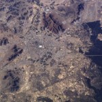
Well, as the days go by, there are more and more indications that an eruption is about to occur in the Harrat Lunayyir region of Saudi…
Al-Qider volcano in western Saudi Arabia. Image courtesy of Ahmed Al-Hussaini
The intense seismicity occurring underneath the Al-Eis region in Saudi Arabia has reached a point where Saudi Arabian officials are requiring 60,000 people who live in the region to evacuate. This is after M4.6 and M5.4 earthquakes that occurred Tuesday night (Saudi time). Saudi officials have also begun to build shelters for people affected by the earthquakes.
Now, the direct connection to a potential eruption is still very much in the air, but the earthquakes are still centered underneath known Holocene volcanic…
Volcano news ahoy, today brought to you by Islands.
Lake Kivu, located along the border the Democratic Republic of the Congo and Rwanda
A gorgeous satellite image (brought to us by the NASA EO) of a steam plume and ash from the ongoing eruption at Shiveluch in Kamchatka. The ash distribution stands out remarkably well on the white snow, with the central circle of ash near the vent/dome and then the wind-aided ash blanketing the terrain to the northeast of the volcano (and a little bit to the south).
Nature has a post reminding us that one of the big hazards at Nyiragongo/Nymuragira is not…
Things are busy - both volcanically and personally - so I'm going to just give you some links to a bunch of exciting/interesting/insane news:
West Mata erupting on May 5, 2009 in the Lau Basin.
According to a bunch of news sources, the eruption at Fernandina in the Galapagos is over (in spanish). That being said, the PNG noted that there is still a lot of carbon dioxide and sulfur dioxide being emitted, suggesting there is still a lot of degassing magma beneath the vents - at what depth (and will it erupt) is the question.
There is a lot of speculation that Nyiragongo (DRC) is erupting or…
UPDATED 3:30PM Pacific: The Associated Press has put up some silent video of the lava flows reaching the ocean at night
The Geophysical Institute in Ecuador is reporting that the eruption at Fernandina in the Galapagos has intensified over the last 24 hours. Heck, the image accompanying the report looks downright apocalyptic:
Now, I'm actually not entirely sure what is being shown in this image. There is no caption, either. My guess is that this is an ocean entry for one of the lava flows, considering the steam and what looks to be water in the foreground. Of course, I have no idea if the…
Has a week gone by already? It is time for another USGS/Smithsonian GVP Weekly Volcano Activity Report.
Highlights (beyond Fernandina, Pagan and Redoubt) include:
A new underwater eruption at NW-Rota 1 in the Mariana Islands.
Increasing seismicity and incandescence from the rhyolite domes forming at Chaiten, Chile.
A spike in sulfur dioxide emissions from Kilauea, Hawai'i to 700 tonnes/day (up from a 2003-07 average of 150 tonnes/day).
4.5-7.5 km / 15-26,000 foot ash columns produced at Shiveluch in Kamchatka from new lava dome.
Continued dome growth and ~6 km / 26,000 foot ash columns from…
Fissure vent eruption from Fernandina in the Galapagos Islands.
In news that comes as a surprise to no one, the current eruption on Fernandina in the Galapagos is having some adverse effect on the wildlife in the Pacific archipelago. Numerous dead fish and sea lions have been seen in the ocean near the actively erupting volcano - now, what exactly is causing the deaths is more speculative. I would imagine with the large plume being produced by the volcano, along with the lava flows reaching the ocean, that volcanic gases and the lava's interaction with the sea water might be the leading…
Popocatépetl from the ISS on January 23, 2001
It might be (and is likely) just normal behavior for Popocatépetl in Mexico, but the volcano produced six plumes over the last 24 hours, according to a report out of Mexico City (in spanish). Officials from El Centro Nacional de Prevención de Desastres (The National Center for the Prevention of Disasters - Cenapred) say that the plumes appear to be mostly water vapor and other volcanic gases, but remind people living near the volcano to be vigilant.
Popocatépetl is only 70 km from Mexico City, so any major eruption from the volcano could…
Image courtesy of AVO/USGS by Cindy Koplin showing the ash fall in Homer, AK on 4/4/09
Not much new to report about the eruption at Redoubt beyond the fact that it continues. AVO has kept the warning level at Red/Warning after briefly dropping it to Orange/Watch on Friday night. The 15,000 foot / 5 km-tall plume on Sunday was mostly water and volcanic gases. Eagle-eyed observers also noticed a plume on the lower flanks on the north side of the volcano that is believed to be steam generated by block & ash flows interacting with snow or water. These flow block & ash flows are coming…
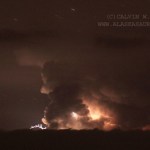
Photo courtesy of Calvin Hall. Taken from March 28, 2009, 50 miles from Redoubt.
Redoubt continues to huff and puff, with an almost constant ash plume of ~15,000 feet / 5,000 meters. This after ~4 PM (Alaska Time), an explosion produced a 25,000 foot / 8,000 meter ash column that disrupted flights in and out of Anchorage again. Also, the air in the Kenai Peninsula area is beginning to feel the effects of the eruption, as AVO notes:
Satellite images from this morning show a broad layer of volcanic haze extending east of the volcano over the Kenai Peninsula, the Anchorage Bowl, and the…
Image by AVO/USGS/Game McGimsey, March 23, 2009
Redoubt has simmered down some today with no new eruptions since yesterday evening. AVO's field crew not only fixed the Hut webcam, but also spotted massive lahar deposits (see above) in the Drift River valley that traveled 35 kilometers downstream and have officials on local and national levels worried about the Drift River Oil Terminal. Funny, it sounds so familiar somehow? As usual, an ounce of planning and thought about locating an oil terminal at the foot of an active volcano would have prevented about 10 tons of problems now.
AVO will be…
The eruption of Hunga Tonga Hunga Ha'apai volcano in Tonga looks to be a big one. Keleti Mafi, head of the Tongan geological service, calls this "a very significant eruption, on quite a large scale", which is no surprise considering some of the spectacular picture we saw of the eruption yesterday. In fact, the eruption is big enough that it has disrupted air traffic over Tonga, as Air New Zealand has issued a warning about the ash column - an ash column that has reached over 15,000 meters/50,000 feet! Luckily for the residents of Tongatapu, a mere 10 kilometers 50 km to the southwest SSE…
Now that Redoubt has decided that Yellow/Advisory is not to its likely and has returned to an Orange/Watch status, I'll continue bringing new updates of the volcano has events unfold.
And nothing much has unfolded since the phreatic explosion that occurred on Sunday. The current state of the volcano, according to AVO, is minor seismic unrest and that is about it. They do offer some more details of the events on Sunday:
An AVO overflight Sunday witnessed activity from 11:30 AM until about 3:00 PM and was able to document ash emission from a new vent, just south of the 1990 lava dome and west…
Photos by Dr. Edward Kohut, all rights reserved, used by permission, 2009
Many times people think that volcanic eruptions affect the economy through the destruction inflicted upon the landscape during an eruption: lahars and pyroclastic flows destroying bridges and homes, ash ruining crops and water, lava flows overunning communities. However, in Hawai'i, a new effect of volcanism has been seen in the agriculture of the state. The volcanic fog - or "vog" as its called - has been causing major problems with farms on the Big Island of Hawai'i. Since the new activity at Halemaumau (see above)…
AVO has officially downgraded the status at Redoubt from "Watch" (orange) to "Advisory" (yellow). The seismicity at the volcano has dropped off for the last couple weeks and signs that an eruption was imminent have waned. This, again, shows the difficulty in trying to predict the behavior of a volcano. All the signs were there at Redoubt - increased seismicity, increased heat flow at the summit (seen as melting ice and increased fumarolic output), increased volcanic gases (CO2 and SO2) - but as of right now, it seems like these signs only pointed to magma moving up the system, but not out of…
Lava issuing from the current eruptions at Kilauea have started a third ocean entry (and the second within the Hawai'i Volcanoes National Park). The entry is not as dramatic as some, forming a slow, dripping entry of lava into the ocean (see linked video footage), but every little drip adds a little more land to the big island of Hawai'i.
In some other Hawaiian volcano news, the USGS have also posted a video showing the filling and draining of the lava lake in Halemaumau that started last year. Usually, the crater was surrounded by steam and fumes from the degassing magma, but the thermal…
Jury duty is done, so here is a little update.
Redoubt is puffing away, producing a more prominent steam plume than it has over the last week (but that may be more weather-related than magma-related.) Beyond that, the volcanic gases keep coming and the earthquakes keep coming.
Guess what?
Still rumbling, still steaming, but still no eruption.
I'll put money on the idea that Redoubt will erupt tomorrow, when I have jury duty.
A week ago, if you asked around, I'm sure most people would have thought Redoubt would have erupted by now considering all the seismicity and melting that was seen at the end of last week. However, volcanology is not an exact science, and here we are continuing to watch Redoubt tease us with signs of pending activity. New holes have appeared in the snow that caps the volcano, the seismicity continues and the volcano is still spewing sulfur dioxide, carbon dioxide and hydrogen sulfide - all signs that magma is intruding the volcanic edifice. However, as on this morning (2/5/2009), the volcano…
One of the more impressive areas I visited while in New Zealand was the Waimangu Valley near Mt. Tarawera (above). The valley itself was created by blast explosions (phreatic explosions) during the 1886 eruption of Mt. Tarawera. These eruptions cut right down the axis of the rhyolite domes (most of which erupted ~1305 A.D.) and extended off the volcanic edifice to form the valley to the west of the volcano. In the valley, no juvenile lava was erupted, instead explosions carved out large pits that formed the Waimangu Valley and today the valley is filled with lakes and thermal features (below…