volcanic gases
The fissure vent eruption near Eyjafjallajokull in Iceland. Image by Ãorsteinn Gunnarsson, March 22, 2010.
It has been hard to keep up with the flood of news from the Eyjafjallajokull eruption in Iceland. Eruptions readers have done a good job with getting new images, videos and info up as they happen, so you might want to peruse the comments for those sorts of tidbits (along with discussion of what might be happening).
Here is the latest:
The eruption at Fimmvörduháls (considering the eruption is actually occurring between the ice caps) could last weeks to months, which isn't too…
The latest in my Volcano Profiles series, this one on Erta Ale in Ethiopia.
The summit crater at Erta Ale in 1994
Location: The Afar region of Ethiopia.
Height: 613 m / 2,011 feet
Tectonic setting: Erta Ale (meaning "smoking mountain") is part of the East African Rift, where the African Continent is tearing apart along a seam that runs from the Red Sea/Gulf of Aden (two other arms of the rift themselves) south through eastern Africa. Many of the large lakes of eastern Africa such as Lakes Albert, Tanganyika, Nyasa and Kariba fill rift valleys created by the cracking of the continental plate…
Catching up with some news:
Anatahan erupting in the northern Mariana Islands in 2003.
I ran across this article right before I got sick, but its been popping up around the interwebs (and is pretty interesting). It details a study in Molecular Ecology that suggests that populations of caribou in Canada's Yukon Territory were strongly effected by the White River Tephra. The White River Tephra is supposedly the largest Holocene plinian tephra (from a ash cloud fallout), with two components dating from ~1900 years ago and ~1250 years ago. The vent for the WRT is likely from a vent beneath the…
A couple bits of news:
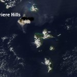
The ash plume from the February 11, 2010 eruption of Soufriere Hills taken by theAqua MODIS camera. Image courtesy of the NASA Earth Observatory.
Flights have been disrupted in the West Indies since last week with the large dome-collapse eruptions of Soufriere Hills on Montserrat. The 10 km / ~35,000 foot ash plume is apparently lingering in the air at commercial flight levels, meaning delays, cancellations or long detours for many flights in the area. Flights in and out of Dominica, Guadelope, Montserrat, Anguilla, St. Kitts and Nevis have all been effected by the…

We've been discussing calderas recently on Eruptions (I wonder why) and the Laacher See in Germany came up. I've actually been to the Laacher See on a field trip lead by one of the world's experts on the caldera, Dr. Gerhard Worner. So, I thought I'd post some pictures and talk a little about this feature that up until maybe 5 years ago, I didn't even know existed.
Laacher See, Germany
The Laacher See is a caldera in the Rhine Valley of Germany (see below). It is only ~30 km south of Bonn and ~60 km south of Koln (Cologne), just to the west of the Rhine River. It is part of the East Eiffel…
With all the talk of the current Yellowstone earthquake swarm, I thought it would worth it to write a post on the the structure and caldera - and why we get earthquake swarms that are structurally rather than magmatically-related.
First off, lets think about why calderas formed. This is relatively simple - at least superficially. The land (or volcano) above a magmatic system is partially supported by that magma, especially because magma is hot and buoyant. The isostatic support by the magma holds up the land surface or volcanic edifice, so when an eruption expels a large volume of magma, this…
First off, I wanted to thank all of the Eruptions readers for making January the most popular month ever on this blog. I suppose I should give an assist to Yellowstone, but really, thanks for coming to the blog, reading the posts and engaging in all the great discussions that go on within its (cyber)walls.
KÄ«lauea's east rift zone eruption site. Image courtesy of the USGS/HVO.
On to some news!
I suppose you've made the big time when you're in the New York Times, and sure enough, the current Yellowstone earthquake swarm is in the Old Grey Lady. Nothing much new to read, but summarizes the…
Some news for the last Friday in January:
Volcanic lightning captured over Redoubt in March 2009.
Tungurahua in Ecuador continues to erupt. Yesterday, the volcano spread ash over much of central Ecuador. Apparently people in Ecuador aren't taking the hazard of ash too seriously, with many ignoring recommendations to wear masks when the ash is falling. Over 50 explosions have been recorded over the last 24 hours at the volcano according to the Ecuadorian Instituto GeofÃsico, most of them small to moderate.
We also have a new USGS/Smithsonian Institute Volcano Activity Report. Much of the "…
Two quick notes:
A Costa Rican farmer evacuating in early January 2010 after renewed activity of Volcan Turrialba.
Well, it appears that after a quiet night on Friday, the current Yellowstone swarm picked up where it left off. We're now up to 1,200 earthquakes since January 17th, with a pair over M3 today. Of course, people are still uppity about the swarm, especially after the earthquake in Haiti, but really, they're about as connected as worrying about the rainy day in Boston when there was a typhoon in Malaysia. Just to get people on the same page, YVO still says: "The swarm events are…
This week's USGS/Smithsonian GVP Volcano Update!
Highlights include:
A volcano I had never heard of in the Kuril islands is showing signs of life: Kharimkotan. Satellite images show a thermal anomaly at the summit of the volcano - its last known eruption was in 1933.
Ash, sulfur dioxide and steam continue to erupt from Nyamuragira in the Congo, although lava flows have abated.
Crater C at Arenal had sporadic strombolian activity - which is par for the course for the Costa Rican volcano.
I must have missed this, but since December 14, the ash erupted at Gaua in Vanuatu has become denser and…
The collapse pit within the Halema`uma`u Crater at Kilauea taken January 7, 2010. Image courtesy of the USGS/HVO.
Eruptions reader Boris Behncke pointed out that things are afoot in the Halema`uma`u Crater at Kilauea. To steal his description: " the lava lake returned triumphantly to the active pit last night, and now it is filling virtually the entire field of the
Halema'uma'u Overlook webcam." Sure enough, checking out the webcam this morning, the field of view is dominated by a lava lake - albeit somewhat crusted over by hardened basalt lava. You can compare the current image with one…
Somehow I haven't posted a bunch of interesting items collected over the last few weeks, so I need to catch up. A pre-emptive hat tip to everyone who has sent me links or notes that might seem familiar in this post.
Tungurahua in Ecuador erupting in 2000.
First off, those of you looking for information on the Haitian earthquake that devastated the capitol Port Au Prince, Highly Allochthonous has post on the tectonics of the quake. Right now, it is hard for me to come up with a worse location in terms of devastation for a quake to have hit in the Caribbean Basin.
Back in volcano news, a lot…
Here it is, my attempt to recap a year's worth of volcanic events. By no means is this supposed to capture every event, but rather the highlight/lowlights and what most captivated me during 2009. I'll be announcing the winner of the 2009 Pliny for Volcanic Event of the Year tomorrow.
Waimangu Geothermal Valley in New Zealand, taken in January 2009 by Erik Klemetti.
January
The year started out with a trip to New Zealand (well, for me at least) and vistas of the Waimangu Valley, formed in the 1886 eruption of Tarawera on the North Island. We were also still thinking about the late 2008…
Looks like last night was busy, volcanically speaking. Eruptions readers noted that VAAC warning of ash from both Mayon (to 10,000 feet / 3.0 km) and Bezymianny (to 32,000 feet / 10 km) were issued {hat tip to Chance Metz for the updates}. Here is some more news on these ongoing events:
Mayon erupting in December 2009.
Mayon, Philippines
Evacuations are continuing near Mayon in the Philippines, some of them forcibly by the local authorities. PHIVOLCS is reporting that SO2 output from Mayon has jumped from ~750 tonnes/day to almost 2,800 tonnes/day over the last 24 hours and seimicity…
It's the last week of classes and it's also AGU (which I will be missing for the first time in 5 years). If you happen to be at the big meeting in SF and hear something you think we'd like to hear, feel free to drop me a line or leave a comment so we can live vicariously through you.
Pyroclastic flows at Sourfriere Hills, December 2009. Image courtesy of MVO.
Some news:
UPDATE 12:40PM 12/14/2009: Just to update the Mayon news from earlier today, PHIVOLC is reporting that lava has been spotting flowing from the main crater on Mayon. Sounds like the eruption we've been waiting for is…
Its already Friday!
News!
Print of the Temple of Jupiter at Pompeii with a steaming Vesuvius in the background.
You can now wander down the streets of ancient Pompeii from the comfort of your own home or office. Google Streetview now cover the streets of the city wiped out by the 79 A.D. eruption of Vesuvius in Italy. Now, some of the articles on the Pompeii streetview give lipservice to the current threat of Vesuvius to the modern city of Naples, my favorite being:
The authorities continually monitor Vesuvius these days, and estimate they'll be able to give adequate warning if it's ever in…
Here is Part 2 of the Q&A with Dr. Boris Behncke. You can also check out Part 1.
Undated image of Stromboli in eruption.
(Shirakawa Akira) 1. Would a large scale eruption (VEI 5 or greater) of Mt. Etna like the ones occurred in 122 BC and 1500 BC (disputed) be possible again in the foreseeable future? Or is the volcano slowly "dying" although the last eruption ended in July 2009 has been one of the longest ever recorded?
2. Not really related to volcanism, but close: does INGV plan to distribute seismic data from seismic stations of its Rete Sismica Nazionale, including stations from…
First off, I want to thank Dr. Behncke for taking the time to answer your questions - and also, thank you to all who sent him some thought-provoking questions. In fact, the questions and answers take up about 12 pages of text, so the Q&A will be divided into two parts.
If you want to see one of the previous in the Q&A series, check out:
Dr. Jonathan Castro.
Question and Answer with Dr. Boris Behncke of the Italian National Institute of Geophysics and Volcanology in Catania.
Dr. Boris Behncke.
Questions for Dr. Boris Behncke
(Bernard Duyck) Qu'en est-il de l'évolution du mécanisme…
All the news to start the week:
Galeras with a grey ash-and-steam plume behind Pasto, Colombia.
Well, after my article on Friday about Colombian volcanoes, Galeras must have decided it was left out. The volcano has been placed back at alert level Orange/II (eruption in days to weeks). An increase in seismicity and sulfur dioxide emissions (in spanish) prompted INGEOMINAS to put Galeras back on higher alert, but now the country has two volcanoes (Galeras and Huila) that could be erupting in the near future.
Back in the Philippines, there is new evidence that Mayon has a new dome forming at…
I did an excellent job of forgetting my notes from GSA 2009, so no wrap up on the meeting until tomorrow, but we do have some new volcano news to digest:
The crater of El Reventador in Ecuador in an undated photo.
Ecuadorian officials have called for evacuations around El Reventador. The Ecuadorian Geophysics Institute says that the volcano's "activities were measured at a level considered high, with permanent seismic signals indicating explosions while the southern side of the volcano crater could be seen as incandescent.". Three provinces near the volcano were put on alert evacuated as a…