ash plume
Classes starting today, so I have to be brief:
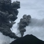
Unique twin ash plumes from Sinabung in Indonesia, erupting on August 29, 2010.
Sinabung
The Indonesian volcano continues to experience explosions, which one last night (well, last night here in Ohio) that prompted an ash advisory for aircraft up to 6,100 m / 20,000 feet, although most reports I've seen pegged the ash column at closer to 2,000 m / ~6,500 feet. Eruptions readers have found a bevy of links for footage and information about the eruption, including a remarkable image gallery from the BBC that shows the volcano exhibiting two ash…
A new Weekly Volcanic Activity Report from the Smithsonian and USGS Global Volcanism Program!
Highlights from this week's report include:
Things are getting a little noisy in Colombia. I mentioned a few weeks ago about a possible explosion at Nevado del Ruiz. Now we have reports of increased seismicity under nearby Cerro MachÃn and ash plumes from Nevado del Huila. After a few centuries of relative quiet, it looks like the volcanoes of the Colombian Andes are looking more lively.
Also in South America, a gas plume was spotted at Chile's Planchon-Peteroa. This is the second time this year…
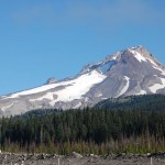
Mt. Hood in Oregon, taken August 2008. Image by Erik Klemetti. Click on the image to see a larger version.
Quick news!
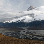
I'm not going to go into too much depth right now about the recent study published in Nature Geoscience on Mt. Hood in Oregon - I plan to talk about it more in a few weeks. Why is that? Well, the lead investigator on the study, Dr. Adam Kent of Oregon State University, is a friend of mine (and occasional Eruptions commenter) so I plan to get the details from him before posting. I was also peripherally associated with some of this work - mostly in the field acting as a pack…
Just a reminder, if you any questions for Sally Kuhn Sennert of the Smithsonian/USGS Global Volcanism Program - about the Weekly Report, about life at the GVP, about volcanoes - be sure to send them to me soon at .
Now, on to this week's update!
Some highlights (not including Gorely):
Lahars from Tungurahua in Ecuador moved blocks upwards of 2 m in diameter downstream over the last week and ash fall was reported over 20 km from the volcano's vent. For some reason, FoxNews decided to use an image of Tungurahua for an article on stats of natural disasters in 2009 - nice image, but the volcano…
The latest news from the world of volcanoes, brought to us by the Global Volcanism Program, USGS and the Smithsonian Institution. They are also brought to us by Sally Kuhn Sennert - and if you have a question for her about her job at the GVP preparing the Weekly Volcanic Activity Report and all things volcanic (and hopefully it won't end like another recent volcanically-mitigated interview).
Some highlights (not including Gorely and Sakurajima):
Ioto (aka Iwojima) in the Volcano Islands of Japan produced an ash plume of unknown height. The volcano has frequent phreatic eruptions and abundant…
News for Monday!
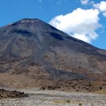
Ngauruhoe in New Zealand, showing the dark lava flows of basaltic andesite on the slopes of the young volcanic cone. Image by Erik Klemetti, taken January 2009.
A couple pieces of news from two Russian volcanoes on the Kamchatka Peninsula: (1) last week's report of activity at Gorely appears to be semi-substantiated with new photos on the KVERT website (Russian). The images from June 6 and 12 (2010) shows steam plumes coming from the volcano - one as tall as 500 meters. Now, this doesn't imply that an eruption occurred, but it might suggest activity on on the upswing. KVERT…
This week went fast, didn't it?
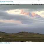
The Baekdu caldera along the North Korean/Chinese border.
The NASA Earth Observatory have been giving us a steady diet of volcanic plumes over the last week, including PNG's Ulawun, Russia's Sarychev Peak (a very faint plume), both an ASTER and Terra image of the summit region at Kliuchevskoi and finally a mix of plume and clouds over PNG's Manam volcano.
I wanted to also mention a brief article I ran into on the Changbaishan/Baekdu caldera along the Chinese and North Korean border. Although short on specifics, this article mentions a number of interesting (…
The latest update from the Smithsonian/USGS Global Volcanism Program!
Highlights (not including Taal, Eyjafjallajökull and Bezymianny) include:
Another thermal anomaly was spotted on an Kuril Island volcano - this one being Tiatia. The volcano has no seismic monitoring network, so the thermal anomaly is all that has been observed.
Lava flows and strombolian explosions continue at Guatemala's Pacaya. Some of the explosions have launched bombs hundreds of meters into the air.
Kliuchevskoi was another busy Russian volcano, with a large thermal anomaly and ash explosions that produced a plume…
The NASA Earth Observatory has been dazzling us with images from the Eyjafjallajökull eruption for months - but they have been dazzling us with volcanoes images for years! Here are two more images for those of you who love seeing volcanoes from above:
Cleveland, Alaska
As I mentioned earlier this week, Cleveland volcano likely had a small eruption over the weekend producing a small ash cloud. Cleveland is already known as an extremely picturesque volcano, both from the ground for its highly conical shape - a textbook andesitic stratocone - and from space. This new June 1 image is from almost…
Tungurahua in Ecuador erupting on May 31, 2010.
Two volcanoes along the edge of the north Pacific had explosive eruptions over the weekend. We have some more details on both of the eruptions, so I'll pass them on:
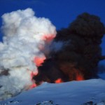
Bezymianny
KVERT is excited because they claim to have predicted the explosive eruption of Bezymianny almost to the day. They had been closely monitoring the volcano and issued this statement on May 20:
According to satellite data by AVO and KVERT staff, a temperature of
the thermal anomaly over the lava dome of Bezymianny volcano began
increasing from May 19 (from -1 (9:49 UTC) to…
Quick news on Memorial Day (in the US at least):
Ash soaked by rain from Tropical Storm Agatha on the roofs of homes in Guatemala after the late May eruption of Pacaya.
Sixteen scientists were evacuated from islands in the northern Marianas due to the eruption of the unnamed submarine volcano south of Sarigan Island. The eruption is continuing to be monitored closely by the USGS and National Weather Service as the plume - which is most steam with minor ash - could disrupt air traffic in/around Saipan. The latest USGS CNMI update:
Seismicity at a single nearby station on Sarigan Island…
Sarigan Island in the northern Mariana Islands. An undersea eruption appears to be underway south of the island.
Thanks to the watchful eye of Eruptions readers, we had an inkling of this eruption the other day, but now we have confirmation that an undersea eruption is underway in the northern Mariana Islands. The exact volcano erupting is unknown, but it appears to be between Anatahan and Sarigan (see below) - both active volcanoes in the Marianas - at a depth of 300 meters. The eruption has been described by the USGS as hot water vapor and an ash plume that might have reached as high as 12…
For all of you going into withdrawal now that Eyjafjallajökull seems to have quieted down, there are two eruptions of note that aren't in the North Atlantic:
Undated image of the Barujari cone at Mt. Rinjani in Indonesia.
Arenal in Costa Rica - which is almost always sputtering away - had a more significant explosive and effusive event today. The volcano produced enough ash, bombs and gas emissions - along with 8 lava flows (or avalanches, depending on the source) - to prompt the evacuation of the National Park around the volcano. Arenal has had numerous strombolian eruptions over the last…
The small steam plume from Eyjafjallajökull on May 23, 2010, where explosive eruptive activity has ceased for now.
The big news over the weekend, at least volcanically, was that Eyjafjallajökull seems to have entered a period of relative quiet. The eruption has died down dramatically, with the last ash explosion occurring two days ago. Since then, the vent has still be producing a significant steam plume that reaches 3 km / 10,000 feet, but none of the ash-laden explosions that marked the earlier parts of the eruption have occurred (meaning the airspace over the North Atlantic and Europe…
News, news, news!
Ash from Eyjafjallajökull piling up on a roof at Seljavellir. Image courtesy of the IMO, by Ari Tryggvason.
The latest from Eyjafjallajökull has the volcano continuing to puff away - producing intermittent airspace closures over Europe. The Icelandic Met Office reports a ~7 km (21,000 foot) ash plume, but they note that the explosivity of the eruption seems to have waned some since a maximum on May 13. Right now, the IMO estimates the eruption rate at ~200 tonnes/second. Lets put that in a little perspective - a Ford F-150 pickup weighs about 2 tonnes, so the volcano is…
Some news for a sleepy Monday:
Mt. Hood in Oregon.
The ash from Eyjafjallajökull is, once again, causing significant airspace closure over northern Europe - close of 1,000 flights today. However, much of the closures are fairly short-lived, but that isn't keeping people happy. The eruption hasn't actually changed much, just that the winds are bringing ash towards Europe. The ash for the next few days will likely effect the England, Scotland, Ireland, Netherlands, France and possibly other parts of northern Europe (along with airspace over Greenland and the north Atlantic). The ash plume is…
Time to play a little catch up ...
Eyjafjallajökull erupting in early May. Image by and courtesy of Martin Rietze.
A brief update on our friend Eyjafjallajökull - the eruption plume from the volcano was considerably taller yesterday, reaching 6-9 km (20,000-30,000 feet), but prevailing winds meant the ash hazard was confined to areas in the middle of the North Atlantic and northern parts of the British Isles. However, even as the ash hazard for Europe wanes (for now), you shouldn't forget the amount of ash being dumped on parts of Iceland. If you want to see some stunning images of the…
An aerial view of Eyjafjallajökull erupting on May 11, 2010, with the extent of the black ash from the eruption on GÃgjökull clearly evident, along with the cracks in the glacier near the lava flow. Photo from the Icelandic Met Office, by Sigurlaug Hjaltadóttir.
Since this past weekend's disruptions due to Eyjafjallajökull, the air over Europe has cleared and most of the airports in Spain, Portugal and Germany (along with those in Morocco) have reopened. The current ash advisory by the London VAAC looks like it will only effect transatlantic flights and Iceland itself, with the ash cloud…
I an in the home stretch for grading exams, so just a quick update for today:
The evidence of floods from the Eyjafjallajökull eruption, taken on May 1, 2010 by Dr. Joe Licciardi.
Airports now as far south as Spain, Morocco and the Canary Islands are facing closures due to the Eyjafjallajökull ash. The latest London VAAC ash advisory has the ash wrapping around western and southern Europe, which I am sure is making life interesting for routing transatlantic flights into Europe. The flights within Europe don't seem to be that effected according to Eurocontrol - and they have even dropped…
A shot of the summit area of Eyjafjallajökull, showing the twin steam-and-ash plumes from the lava flow and active vent. Picture taken by Dr. Joseph Licciardi (UNH).
Over the weekend, the newly reinvigorated ash eruptions from Eyjafjallajökull combined with favorable winds meant that ash from the eruption closed airspace over swaths of Europe, including Ireland, Spain, Portugal, Italy, Austria and Germany. These disruptions are continuing into the new week, although most of the disruption is for transatlantic flights. However, the threat of ash is more present than ever, as Ryanair…