basaltic eruption
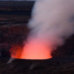
A quick update on the rockfall in the Halema`uma`u (got it right this time!) Crater at Kilauea. Last week a rockfall blocked the vent that had been glowing for most of the year from the lava below, but the debris clogged the vent, producing minor accidental tephra explosion.
Lava in the recently "clogged" Halema`uma`u vent at Kilauea. Taken July 6, 2009, courtesy of HVO.
Well, it didn't take long for lava to retake the "clogged" vent. New video from HVO shows lava bubbling back up through the clogged vent (see the video in the above link). The lava has formed a small lava and even produced…
The Halema'uma'u Crater at Kilauea on June 29, 2009, prior to a rockfall on June 30th that has blocked the vent. Image courtesy of HVO.
There is a bit of a buzz today about significant rockfalls that occurred in Halema'uma'u Crater at Kilauea on June 30th. Some articles have suggested that the rockfall has "snuffed out" glowing vent in the Crater. Well, this is partially true. HVO is reporting that the glow that has been seen at Halema`uma`uma has been, in fact, gone since the rockfall. Here is the report of the event:
A sequence of rockfalls, some quite large, within the Halema'uma'u vent…
Some volcano news before the weekend:
The Barujari vent at Mt. Rinjani erupting in May 2009.
Barujari, the small basaltic volcano located in the crater at Mt. Rinjani, is "spewing 200-meter-high lava", at least according to recent reports. It is unclear if the eruption is, in fact, a fountain or merely strombolian activity throwing incandescent blocks that high (see above). My guess is that it is the latter, as that is much more typical for Barujari. Another report mentions a 600 meter "river of lava" (in spanish) that ends at Segara Anak lake. The volcano has been erupting all spring with…
UPDATE 5/21/2009 4:30 PM Pacific: The latest news suggests that there are little to no evidence of volcanic gases since Wednesday according to the SGS, but they continue to monitor.
Lava flows from a 1256 A.D. eruption near Medinah in Saudi Arabia (to the south of Harrat Lunayyir) taken by the crew of the ISS in 2004. It shows nicely the volcanic heritage (dark lava flow on right of image) in western Saudi Arabia. Image courtesy of JSC Earth Observation Lab.
Well, as the days go by, there are more and more indications that an eruption is about to occur in the Harrat Lunayyir region of Saudi…
Mauna Kea from space taken April 2009. Image courtesy of the NASA EO.
Just a quick link to a stunning photo of Mauna Kea in Hawai'i taken April 29, 2009 from the International Space Station. You can clearly see the pyroclastic material and abundant cinder cones that litter the flanks of the volcano.
{Thanks to the NASA Earth Observatory for the image link.}
Al-Baidha volcanoAl-Qider volcano in Saudi Arabia. Image courtesy of Ahmed Al-Hussaini.
I've been searching for more information on the Saudi Arabian earthquake swarm reported last week. A number of Eruptions readers have also added some on-the-ground info as well.
UPDATE 12:30PM Pacific: Here is a brief update via Reuters India. They mention that five villages are being evacuated as a precaution. Beyond that, not much new information and it does feature this line that makes me shudder: "The region lies on a fault line, according to SGS, which declined to comment on current magma levels,…
The Harrat Khaybar volcanic field in Saudi Arabia. Image courtesy of NASA, taken in 2008.
Now, I might take this report with a Volvo-sized grain of salt, but I've seen a few reports lately of an earthquake swarm going on in Saudi Arabia, near the Harrat Ash-Shaqqah in Al-Eis region (apparently near Madina, but I'm not 100% sure). I might normally just chalk this up to the tectonics of the Arabian Plate, however, the latest article I read this morning, Saleh Al-Muhawis, Director General of the Civil Defense in Madina Region mentioned this as the cause of the seismicity:
... magma (molten…
UPDATED 3:30PM Pacific: The Associated Press has put up some silent video of the lava flows reaching the ocean at night
The Geophysical Institute in Ecuador is reporting that the eruption at Fernandina in the Galapagos has intensified over the last 24 hours. Heck, the image accompanying the report looks downright apocalyptic:
Now, I'm actually not entirely sure what is being shown in this image. There is no caption, either. My guess is that this is an ocean entry for one of the lava flows, considering the steam and what looks to be water in the foreground. Of course, I have no idea if the…
Fernandina in the Galapagos erupting in April 2009. Image courtesy of NASA.
The latest reports about the ongoing eruption at Fernandina are both coming and going. Reports from officials in the Galapagos National Park suggest that the eruption was become more intense (in spanish), while later reports from the Geophysical Institute in Ecuador say that the eruption is waning. Both reports might be true and reflect the volatile nature of the eruption, but overall it seems that the wildlife (that probably is used to this sort of thing anyway) hasn't been effected too much by the eruption.
It has been rather quiet on the volcano-front in the last week. Redoubt and Llaima (in spanish), after a few weeks of intense eruption, are both back on Orange Alert. News of the eruptions from Hunga Tonga Hunga Ha'apai and Fernandina is rather sparse in the details. The news of volcanism in 2009 seems to have settled down.
A few tidbits I caught over the weekend:
Chaiten
Damage wrought by the eruption of Chaiten on the town of Chaiten in Chile, taken in early December 2008. Image courtesy of the NASA Earth Observatory.
Don't you feel like you're read this sort of story before after other…
Fissure vent eruption from Fernandina in the Galapagos Islands.
In news that comes as a surprise to no one, the current eruption on Fernandina in the Galapagos is having some adverse effect on the wildlife in the Pacific archipelago. Numerous dead fish and sea lions have been seen in the ocean near the actively erupting volcano - now, what exactly is causing the deaths is more speculative. I would imagine with the large plume being produced by the volcano, along with the lava flows reaching the ocean, that volcanic gases and the lava's interaction with the sea water might be the leading…
Fernandina, Ecuador
Fernandina erupting in 2009.
UPDATE 4/13/09 at 12PM: The NASA Earth Observatory has posted a nice MODIS image showing the plume from the Fernandina eruption drifting out over the Pacific.
We have a few more details on the ongoing eruption at Fernandina in the Galapagos Islands. Officials from the Parque Nacional Galápagos (PNG) flew over the island (in spanish) and saw the eruption is coming from a several-kilometer-long fissure vent that flows towards the sea, dividing into multiple flows and then coalescing when it reaches the sea. There is also a lot of vapor being…
Goma after the 2002 Eruption of Nyiragongo
The activity at Redoubt has captivated a lot of us, but in the grand scheme of things, its eruption are more likely to caused inconvenience and property damage rather than dramatically loss of life (unless something huge and unexpected occurs). However, the same cannot be said if Nyiragongo and/or Nyamuragira (a.k.a. Nyamulagira) in the Congo were to erupt. These volcanoes are close to the city of Goma, a city of nearly 600,000, not including refugees from the fighting in the region. Eruptions of Nyiragongo in 2002 prompted the displacement of 400,…
Its been a busy week for volcanoes between the headline capturing Tongan and Alaska eruptions. Catch up on what you might have missed with the latest SI/USGS Weekly Volcano Report (for 3/18-3/24). Highlights (beyond Hunga Tonga Hunga Ha'apai and Redoubt) include:
Galeras, Colombia has settled down a bit
More block-and-ash flows from the two dome complexes growing at Chaiten, Chile
Strombolian eruptions at Mt. Etna, Italy
Plumes of steam and minor ash were reported from Popocatépetl, Mexico
A small lahar was seen at Tungurahua, Ecuador
Ash plumes and incandescent tephra explosions were…
Mauna Loa fire fountains in 1984
For those of you looking for some non-Redoubt-related volcano news, you can take a look at the 25th anniversary of the last eruption at Mauna Loa (there is some nice video footage provided by KHNL if you follow the link). By no means is this volcano "dormant", but rather this is a typical lull in activity at the Hawaiian shield volcano. Its neighbor, Kilauea, has been erupting for decades, but the last major eruption at Mauna Loa was in 1984, when the volcano sent lava downslope with 3,000 feet of Hilo, moving 15 miles in a few days. Monitoring at Mauna Loa…
Photos by Dr. Edward Kohut, all rights reserved, used by permission, 2009
Many times people think that volcanic eruptions affect the economy through the destruction inflicted upon the landscape during an eruption: lahars and pyroclastic flows destroying bridges and homes, ash ruining crops and water, lava flows overunning communities. However, in Hawai'i, a new effect of volcanism has been seen in the agriculture of the state. The volcanic fog - or "vog" as its called - has been causing major problems with farms on the Big Island of Hawai'i. Since the new activity at Halemaumau (see above)…
Lava issuing from the current eruptions at Kilauea have started a third ocean entry (and the second within the Hawai'i Volcanoes National Park). The entry is not as dramatic as some, forming a slow, dripping entry of lava into the ocean (see linked video footage), but every little drip adds a little more land to the big island of Hawai'i.
In some other Hawaiian volcano news, the USGS have also posted a video showing the filling and draining of the lava lake in Halemaumau that started last year. Usually, the crater was surrounded by steam and fumes from the degassing magma, but the thermal…
For those of you interested in what happens in the realm of submarine volcanism, I can pass on some tidbits I've gotten about NW-Rota 1, a submarine volcano in the Mariana Islands (see bathymetry above). Dr. Ed Kohut (Petrogenex), a friend of mine from my days at Oregon State Univ., is currently on a JAMSTEC research cruise in the Mariana Islands, visiting the area about NW Rota-1. He reports:
"We just reached NW-Rota 1. It is still actively erupting. To put that in perspective, it has been observed erupting every time it has been visited since 2003. Today's actvity is not as…
One of the more impressive areas I visited while in New Zealand was the Waimangu Valley near Mt. Tarawera (above). The valley itself was created by blast explosions (phreatic explosions) during the 1886 eruption of Mt. Tarawera. These eruptions cut right down the axis of the rhyolite domes (most of which erupted ~1305 A.D.) and extended off the volcanic edifice to form the valley to the west of the volcano. In the valley, no juvenile lava was erupted, instead explosions carved out large pits that formed the Waimangu Valley and today the valley is filled with lakes and thermal features (below…
I made it back from New Zealand yesterday after spending the last two weeks looking at some of the most remarkable volcanic landscapes you could imagine. I'll add more detail soon for those of you interested in the volcanism of the North Island, but I'll leave you with a picture of yours truly in from of Ngauruhoe (a.k.a Mt. Doom) along the Tongariro Crossing. The volcano last erupted in 1977 and it considering the youngest vent of Tongariro. Ngauruhoe has had >60 eruptions over the last 150 years.