hurricanes
Climate Denial Crock of the Week gives us this new video. Details here.
We are not yet where we need to be with this "when did you stop beating your wife" question sometimes in the form of:
"Can you REALLY attribute ANY storm to Global Warming, really? No? Then is global warming really real? Really?")
Next time someone says something like that to you, consider answering the question with a question:
"Which major storm of the last two decades or so did not include any of the extra climatic energy provided to this planet by the release of fossil Carbon and other greenhouse gasses into…
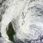
As pretty much everyone should be aware already, Hurricane Sandy is getting close to landfall in the New Jersey area where it will collide with a strong winter storm coming down from Canada. It seems no one really knows what will happen, but all the people who should agree it will be very bad. This storm is huge. Added into the mix is a full moon causing the highest high tides of the year.
As usual, for the most comprehensive coverage of weather events the go-to place is Jeff Master's Weather Wunderground. The latest posting:
Hurricane Sandy has changed little in…
Mark Pendergrast writes: To kick off this book club discussion of Inside the Outbreaks, I thought I would explain briefly how I came to write the book and then suggest some possible topics for discussion.
The origin of the book goes back to an email I got in 2004 from my old high school and college friend, Andy Vernon, who wrote that I should consider writing the history of the EIS. I emailed back to say that I was honored, but what was the EIS? I had never heard of it. I knew Andy worked on tuberculosis at the CDC, but I didn't know that he had been a state-based EIS officer from 1978…
The 2010 hurricane season has begun, and has done so with a hard blow to Guatemala, including dozens of fatalities (83 so far). Ironically, this storm was not particularily violent, not even getting above tropical storm status, but the rainfall was very intense.
As always, the best place to follow the hurricane season is Jeff Master's Weather Underground.
His introductory pst to this season lists the following reasons to worry about the months ahead:
"unprecedented sea surface temperatures in the Atlantic"
the ending of El Nino conditions
a million refugees from the recent earthquake in…
Today marks the official start of North Atlantic hurricane season. So...
One of the key differences between genuine climatology and anti-scientific denialism of anthropogenic climate change is the flexibility of the former and the stubbornness of the latter when it comes to our ever-evolving understanding of how the world works. The connection between hurricanes and climate is a perfect example.
When the "An Inconvenient Truth" crew was filming Al Gore deliver his now-familiar presentation, they couldn't have anticipated that two major hurricanes would, as if on cue, roar through the Gulf of…
It's a sore spot for some climate change pseudoskeptics. Any time anyone makes any kind of claim about the effects of a warming planet on tropical storm activity, you can count on a deluge of rejoinders about how shaky the science on the subject really is.
Much is made of Al Gore's use of an image of hurricane spewing forth from a smokestack on a promotional poster for "An Inconvenient Truth." And Chris Mooney devoted an entire book to exploring the science, and the battles over and about the science, Storm World. I was commissioned by the Weather Channel a couple of years back to write a…
In 2005, corals in the large reef off the coast of Florida were saved by four hurricanes. Tropical storms seem to be unlikely heroes for any living thing. Indeed, coral reefs directly in the way of a hurricane, or even up to 90km from its centre, suffer serious physical damage. But Derek Manzello from the National Oceanic and Atmospheric Administation has found that corals just outside the storm's path reap an unexpected benefit.
Hurricanes can significantly cool large stretches of ocean as they pass overhead, by drawing up cooler water from the sea floor. And this cooling effect,…
Yale Environment 360 interviews the renowned New Yorker journalist, who blames the media and scientists alike for our staggering failure to deal with this issue. Here's a long quotation:
e360: We've talked about journalists and generally the challenges in conveying this issue to the public. But what about scientists? I mean, scientists have a responsibility to get their information out to the public whether it's through the media or through their own writings and work. How good a job do you think they have done in conveying this whole issue?
Kolbert: Oh, I don't think they've done a good job…
My latest Science Progress column is up: It makes the case that Stephen Colbert is the heir to Johnny Carson in terms of talk show promotion of science.
It also includes various lame and stupid talking points that I made up and didn't use on the show, such as the following hypothetical Q&A responses:
Didn't scientists start the "war" in the first place? Didn't they commit acts of aggression?
Yes, if you mean by learning things.
Why should I care about science?
Because America is really good at it--much better than France.
Is there really a "war" on science? Where are the bodies?
Well,…
Although there was not much buzz about hurricanes this season (which is not quite over yet), this year has in fact set a few records. I guess since New Orleans (narrowly) escaped Gustav there seems so much less to talk about!
Well, New Scientist has an article about some of the things that are worth noticing about the 2008 Atlantic hurricane season.
Perhaps the most notable record is "for the first time major hurricanes formed in five successive months, from July through November." Hurricane Paloma reached category 4 this month (November) and battered poor Cuba for the fourth time this…
The Red Cross is providing shelter, food, and emotional support for thousands in need after Hurricane Ike. Make a donation here.
Photo credit: USGS
Tropical Storm Ike intensified into a hurricane today, and then rapidly intensified into a sudden Category 3 storm, our third major hurricane of the year. And instead of recurving northward, as hurricanes at its location tend to do, Ike is forecast to plow straight towards Cuba and Hispaniola, and possibly threaten the United States.
All of which is so not cool....but just more proof that this hurricane season is far, far from over.
To that end, my latest Science Progress column is an attempt to seize the moment to direct attention beyond Anderson Cooper dodging flying billboards on CNN, and…
Here I am, at my parents house. There is no power at my house and Louisiana in September with no power is really a whole bunch of no-fun. But maybe I can use this time to talk about science.
**The Nature of Science**
Here is a review. What is science all about? (I am pretty sure I talked about this before) Science is about making observations and from those observations creating models. If the model predicts other things that are confirmed, then that is good. If not, the model must be changed. Really, it's that simple.
**Hurricane Models**
It is somewhat interesting that forecasting…
There is so much to worry about with this storm...and also, just maybe, a ray of hope.
Gustav has not explosively intensified over the Gulf of Mexico loop current, as feared. It is now a 100 knot Category 3 storm, with some intensification forecast before landfall, but not too, too much. Meanwhile, the landfall forecast is shifting to the left/west...a trend which, if it continues, could be quite a good thing for New Orleans. (Eric Berger certainly thinks so; Jeff Masters though is still very worried.)
The point is, this one is going to go down to the wire. I can't say, and neither can…
The latest report is that maximum sustained winds have jumped all the way up to 125 knots. Frankly, I wouldn't be at all surprised to see Category 5 at some point on Gustav's highly ocean-heat laden journey.
I just talked to the family in New Orleans. They are in Pensacola, and headed to Atlanta....
Gustav is now a major hurricane headed toward Louisiana with estimated surface winds of 120 mph. He's expected to make landfall late Monday or early Tuesday.
Values of Tropical Cyclone Heat Potential (TCHP) over 80 are often associated with rapid intensification of hurricanes. More from Jeff Masters.
We knew Katrina was coming and now Hurricane Gustav looks set to get uncomfortably close to New Orleans. While models suggest Gustav will just miss the city, Jeff Masters has advised residents to leave given the small chance of a Category 3 storm surge. More at the National Hurricane Center.
In January of 2003, I sat in Joe Kelley's seminar at the University of Maine as he foretold the devastation that was to come to New Orleans. I'd never heard this chilling story before and listened intently as he explained that as far back as when The Big Easy flooded in the 1920's, scientists realized that the Mississippi Delta would continue to change its course (rivers have a habit of doing that you see). I began to understand that over time, the already vulnerable city faced increasing threat and felt dizzy amid the whirlwind of so many alarming facts and figures.
The levees are…
[Tropical Storm Gustav coming off Haiti and reorganizing.]
It has been almost three full years since a major hurricane hit the United States. The last one was 2005's Wilma.
We aren't really used to this any more. 2004 and 2005 are slipping deeper and deeper into our memories...but they shouldn't.
Now, unfortunately, the current Tropical Storm Gustav may remind us of what it's like. The storm has got a whole lot of hot water ahead of it, and a track that looks pretty certain to bring it straight into the Gulf of Mexico. After that, who knows precisely where landfall will occur, but as Jeff…
This is not good. The pressure reported by the National Hurricane Center was 976, then 972, then 967....meanwhile, the storm has developed a perfect eye:
The Advanced Dvorak Technique, a computer program being run by folks at the University of Wisconsin that assesses storm intensity, now shows a major rapid intensification burst:
I can only expect that when the National Hurricane Center next reports, it will be calling this storm a Category 2 or even perhaps a Category 3....