remote sensing
Your weekly dose of volcanism from the USGS/Smithsonian Global Volcanism Program.
Highlights (not counting Mayon), include:
The activity at Mando Hararo in Ethiopia appears to be a fissure eruption. Ground observations saw a 4-5 kilometers / ~2.5-3 mile fissure with new predominantly 'a'a lava flows that were 2-3 m thick ... the fissure was lined with scoria ramparts 30-50 m high. They did not see any active lava, though.
As some Eruptions readers have pointed out from the OMI SO2 maps, Sarychev Peak (Russia) is still producing gas-and-steam (with some ash) plumes, mostly drifting off to the…
All the volcano news that is fit to print, all thanks to the USGS/Smithsonian GVP!
Highlights (not include Manda Hararo, Kilauea and Mayon) include
San Miguel in El Salvador has been experiencing increased seismicity. The last time the volcano erupted was in 2002.
A pilot spotted a ~10,000 foot / 3 km ash plume emanating from Anak Krakatau in Indonesia.
Another ash plume, this time at Ubinas, Peru, was spotted by pilots rising to ~6.7-9.1 km / 20-30,000 feet.
Explosions were heard from Suwanose-jima in Japan, but no associated ash plumes were spotted.
It sounds like a lava dome has been…
Two papers submitted, one to go. Keeps you quite busy, let me tell you.
Lava flow from a 2006 eruption on Mayon in the Philippines.
A few bits of news today:
A few more details about the ongoing watch of Mayon in the Philippines . There have been apparently no changes in the shape of the floor of the crater as you might expect if magma was rising underneath. However, there has been an overall inflation of Mayon since the unrest began a few weeks ago. PHIVOLCS will be checking the sulfur dioxide and carbon dioxide output of the volcano soon as well.
Lots of articles this week about the "…
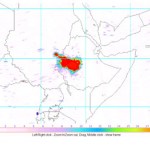
Three days ago, I received an email from Eruptions reader Gijs de Reijke who was curious about something he noticed in the daily OMI SO2 images:
OMI sulfur dioxide map over Ethiopia for June 30, 2009.
Now, I wasn't quite sure what to make of it other than the fact that there was an awful lot of sulfur dioxide in the vicinity of Addis Ababa, which seemed odd. If we look at a map of the active volcanoes in Ethiopia (below), a majority of the ones we might suspect if the SO2 was volcano are to the north (Erte Ale, Dallafilla), but this patch is smack-dab in the middle of the country, looking…
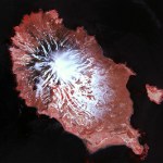
The NASA Earth Observatory has posted some excellent images of Matua Island in the Kurils that show the before and after of the Sarychev Peak eruption of June 2009. There are some impressive changes ... so lets see if you can spot them! Post your comments on whats changed and why and I'll chime in periodically with what I've noticed.
BEFORE: Matua Island and Sarychev Peak in May 2007 (big version)
AFTER: Matua Island and Sarychev Peak in late June 2009 (big version)
The Q&A post will be coming over the weekend (there's still time to send me a question!)
Icy cold volcanoes (well, geysers) on Enceladus, a moon of Saturn.
In the meantime, here are a few quick hits:
Mt. Cleveland in the Aleutians had a small eruption. The plume was only ~15,000 feet / ~3 km. Cleveland is one of the more active volcanoes in the Aleutians, so this eruption is not out of the norm.
Landslides and rockfalls at Arenal (in spanish) in Costa Rica continue to prompt evacuations of tourists near the volcano. It is interesting to note that officials don't seem worried about hotel…
Flight path for Continental Flight 009 from Newark to Tokyo, diverted back to Newark due to the threat of ash from Sarychev Peak. Image courtesy of Flight Aware.
The eruption at Sarychev Peak is continuing to disrupt all sorts of flights that head towards Asia. There are lots of unhappy travelers who have had to "enjoy" a 12 hour flight that took them from Newark, NJ to ... Newark, NJ (see yesterday's Continental Flight 009 above). There have been a multitude of flights affected by the ash, many reported here on Eruptions by travelers or relatives (keep them coming!) It will be interesting…
Matua Islands (also known as Matsuwa Island), home of Sarychev Peak.
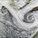
The eruption of Sarychev Peak in the Kuril Islands has been wreaking havoc on flights to and from Asia for the past few days (as many Eruptions readers can attest). You can see the latest VAAC (Volcano Ash Advisory Center) statement here that shows ash to at least FL380 (38,000 feet / 11 km). Predicted ash movement (see below) for the next couple of days has ash moving to the southeast of the volcano and the U.S. Air Force has detected ash as far as 1500 miles / 2400 km southeast and 575 miles / 900 km northwest of the…
Sarychev Peak in Russia erupting on June 14, 2009. Image courtesy of the NASA Earth Observatory.
The transpacific air routes over the Aleutians, the Kamchatka Peninsula and the Kuril Islands are a prime location for the threat of ash to commercial aviation. Many of these volcanoes, especially on the western side of the Pacific Ocean are not closely monitoring and sometimes only remote sensing techniques can keep track of the activity.
Case in point is the current eruption at Sarychev Peak in the Kuril Islands. The volcano is on one of the southern-most Kuril Islands (Ostrov Matua) in Russia…
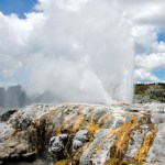
Pohutu Geyser in Rotorua, New Zealand. Image taken by Erik Klemetti in January 2009.
It has been busy busy week for me, capped off today with a talk about my field work in New Zealand (see above), so I don't have much to say. Not much new news today about the Saudi Arabian earthquake swarms, but again, I'll keep my eyes pealed (incidentally, I still haven't been able to figure out why no western news sources have even mentioned the swarm).
Anyway, here's are some volcanic tidbits to enjoy over the long weekend:
Vog, as seen from space. Volcanic fog, fashionably shortened to "vog" is a real…
Nyiragongo as seen from Goma, Congo in 2002.
There isn't much to go on so far, but there are indications that an eruption has started at Nyiragongo in the Democratic Republic of Congo. Satellite images has found "thermal anomalies" at the summit and along a 3-km swath of the eastern and western slopes. The report mentions that these could be "fires and /or volcanic material" and more interestingly, noticed at least 6 times since April 10, 2009. From the sound of it, this might be multiple vents or a central summit vent with lava flows going to multiple sides of the volcano. The Volcanism…
Let me now sing the praises of NASA's Earth Observatory, a phenomenal web-based public education resource that is celebrating its 10th birthday today. Every day for the past decade, NASA has been uploading spectacular remote sensing images and astronaut photographs and accompanying them with clearly written, jargon-free but scientifically accurate explanations of the pictured phenomena. The Earth Observatory is one of my favorite web destinations, and I get their weekly email newsletter, and follow them on twitter. (Follow me!)
On numerous occasions, I've used Earth Observatory images to…
Mt. Pinatubo, Philippines taken by STS-050 in July 1992. Image courtesy of the NASA Earth Observatory
Few websites offer so many unique views of active volcanism than the NASA Earth Observatory. That is why I'd like to wish the EO a happy 10th birthday. The website first came online April 29, 1999. Keep up the good work and here's to more stunning volcano images (like the one above of Mt. Pinatubo) to come!
Well, after lamenting the slow volcano news, things are beginning to pick up again. Beyond the news of a potential increase in activity at Anak Krakatau, there are a few other newsworthy bits that have come up:
Mt. Kerinci in Indonesia
Mt. Kerinci in Indonesia is showing signs of eruption. The volcano is the highest mountain on the island of Sumatra, reaching 3,800 m / 12,400 feet and last erupted in March 2008. Its volcanic activity is marked by small (VEI 2) explosions of ash and tephra. Currently, the volcano is experiencing increased tremors and minor explosions that rained ash on a tea…
The weekend is rolling in and I might end up spending most of it in the 90+ degree California weather, so unless something big comes up (volcanically), I'll leave you with a few news bits.
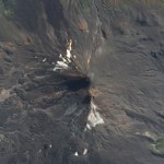
Llaima
Llaima in April 2009. Image courtesy of the NASA Earth Observatory
This is a true color image of Llaima in Chile, provided by the great folks at the NASA Earth Observatory. You can clearly see the dark grey new tephra on the main summit cone along with the grey ash covering the snow on the southwestern part of the volcano (north is up). A few other fun features are some smaller parasitic cones in…
Fissure vent eruption from Fernandina in the Galapagos Islands.
In news that comes as a surprise to no one, the current eruption on Fernandina in the Galapagos is having some adverse effect on the wildlife in the Pacific archipelago. Numerous dead fish and sea lions have been seen in the ocean near the actively erupting volcano - now, what exactly is causing the deaths is more speculative. I would imagine with the large plume being produced by the volcano, along with the lava flows reaching the ocean, that volcanic gases and the lava's interaction with the sea water might be the leading…
Mount Pagan in the Mariana Islands erupting on April 15, 2009. Image courtesy of the NASA Earth Observatory.
Up until fairly recently, a lot of volcanoes got away with erupting without anyone knowing the better. However, with all the "eyes in the sky" we have these days, even remote oceanic volcanoes get caught in the act of erupting. Case in point is this image (above) of Mt. Pagan in the Mariana Islands erupting. It was captured by the MODIS satellite yesterday and it shows a health ash plume emanating from the volcano. Pagan is an oceanic stratovolcano on the sparsely populated island of…
Fernandina volcano in the Galapagos.
Fernandina in the Galapagos has entered a new eruptive phase according to the Geophysical Institute (GI) at the National University of Ecuador (in spanish). Satellite images show a new crater and ash column from the volcano and the GI will look for evidence of new lava flows beyond the "hot points" spotted on the satellite images.
UPDATE 4/11/09 9PM: I thought I'd add a link to the story in English now that I found one. There are also some pictures of the lava flows from La Cumbre (There is some confusion about name - Fernandina and La Cumbre are the…
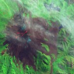
Llaima in Chile, taken on April 9, 2009. Image courtesy of the NASA Earth Observatory.
The NASA Earth Observatory (currently celebrating its 10th year) has posted a number of great images of the current eruption of Llaima in Chile, taken from Earth Observing-1 and Terra Satellites. They show both the ash plume of the eruption and the lava flows associated with it (above). The image here is a false-color image of Llaima, where the bright red/orange is the lava flow from the volcano, along with the dark brown of the ash/rocks from this and previous eruptions.
The eruption itself might continue…
Image courtesy of KVERT, taken by L. Kotenko on Marhc 18, 2009.
To me, one volcanic arc about which I wish I knew more is the Kuril-Kamchatka arc. I'm well aware of how active it is, with giants composite volcanoes like Bezymianny, Koryak, Klyuchevskoi and many, many others. This arc of volcanoes, although in a sparsely populated part of the world, is important to monitor due to its proximity of air travel lanes to Asia. So, any time I find out a volcano in this area - usually one that I was previously unfamiliar - erupted, I am excited.
Today's example: Ebeko. Never heard of it. Yet, it is…