Severe weather
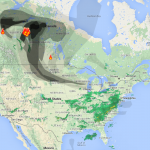
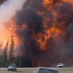
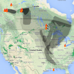
Remember that big wild fire that threatened, and damaged, Fort MacMurray, causing major evacuation in the oil sands mining region of Canada?
Well, the fire never went out and has now changed directions to threaten settlements again.
__________
Update (mid day Tuesday): The fire is now actually burning some homes/buildings in Ft. McMurray. One of them may have actually exploded. Maybe two.
On the other hand, the oil sands camps to the north seem to be less threatened, or not threatened. The area around these sites are clear of major vegetation, and there are "industrial firefighters" on the…
This year's Atlantic Hurricane season will be stronger, forecasts suggest, than that of the previous two years, and stronger than the average year.
The Atlantic Hurricane Seasons starts on June 1st. But, there was a hurricane that happened already, either late in last year's season or very early in this year's season, called Alex. That hurricane had to go somewhere, and I suppose the keepers of the records had already put their spreadsheet to bed when Alex came along on January 7th, so that storm gets counted as part of the season that will nominally start at the beginning of next month.…
This is a segment of The Big Picture with Thom Hartmann, in which climate scientist Professor Michael Mann provides important perspective on the link between climate change and other disasters such as tornadoes. (See also: The Meaning of the Fort McMurray Fire).
Michael Mann is the author of The Hockey Stick and the Climate Wars: Dispatches from the Front Lines, and Dire Predictions, 2nd Edition: Understanding Climate Change (a visually rich summary of the most recent IPCC report) as well as the forthcoming book combining climate science and political cartooning, The Madhouse Effect: How…
The Climate Change Connection
It is hard to understand the connection between climate change and wild fire. This is in part because it is hard to understand the factors that determine the frequency and extent of wild fires to begin with, and partly because of the messiness of the conversation about climate change and fire. I'm going to try to make this simple, I don't expect to succeed, but maybe we can achieve a somewhat improved understanding.
Fires have to start, then they burn for a while, then they stop.
Most wild fires are probably started by humans. This does not mean that human…
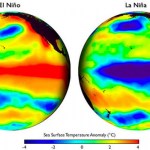
The US NOAA has this video summarizing what they expect for weather in the US as the result of the current, winding down, El Nino:
(function(d, s, id) { var js, fjs = d.getElementsByTagName(s)[0]; if (d.getElementById(id)) return; js = d.createElement(s); js.id = id; js.src = "//connect.facebook.net/en_US/sdk.js#xfbml=1&version=v2.3"; fjs.parentNode.insertBefore(js, fjs);}(document, 'script', 'facebook-jssdk'));
2016 Spring Climate and Flood Outlook
As a near-record El Niño begins to wind down, NOAA issued its spring seasonal outlooks for flooding, drought, precipitation, and…
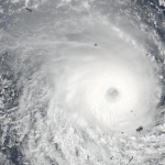
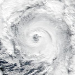
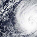
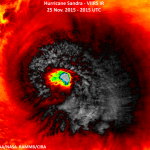
Tropical cyclone Winston is now a Category 4 storm and is probably going to make a direct hit on Fiji, tomorrow, Saturday. It will likely be a record storm for Fiji.
The storm is fueled by high sea surface temperatures, which extend to a significant depth, which probably caused the storm to intensify rapidly and to such a high state.
Jeff Masters and Bob Henson have written up the important information on this storm, here.
Fiji has been hit with a number of bad tropical storms, mainly concentrated in recent decades.
UPDATE (Friday PM Central)
Jeff Masters and Bob Henson are now…
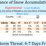
Storms like last weekend's blizzard and widespread snowfall can happen, in theory, any winter, but large snowfall storms in the US Northeast have been significantly more common in recent years than in previous recorded history. Over the last few years we've seen these large snowfalls happen farther south than usual, as was the case with the 2016 Blizzard. Climate scientists are pretty sure that this blizzard was either outright caused or significantly enhanced (you really can't tell the difference) by human caused global warming. How can a blizzard, a big cold thing, be caused by warming…
According to Paul Douglas (pers. com) there is some important news on what Jonas still has planned.
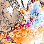
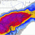
There is likely to be major flooding along the coast of Cape May, and in some areas of New Jersey there may be coastal flooding nearly of the magnitude that happened with Superstorm Sandy. So far storm surges have exceeded the original predictions.
The region from Washington DC to New York is likely to have another half foot or more of snow, and storm totals will be two to three feet with much larger drifts over that area. This snow will taper off this evening over much of the area.
The map…
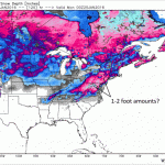
Friday AM Update: Overall the storm has shifted north. Washington DC is still on track to have something close to two feet of snow in the city, more to the west. The predicted snowfall for New York City, the city that eats meteorologists, is increasing, and The City may see a foot or more, with closer to two feet to the northwest. DC will have its most intensive snowfall during the night on Friday, while New York City will have most of its snow falling during the day on Saturday.
With this northward shift, Boston is likely to get more snow too, possibly over a foot. Snow will start there…
GO HERE FOR THE LATEST UPDATE
See below for update
Jonas, (and no, I do not condone naming of storms that are not tropical cyclones) is going to do bad things to the US East Coast and hinterland.
Imma let you get back to setting your hair on fire over this storm, but first I want to 'splain something to you.
A big No'reaster like this is a big swirling fast moving low pressure system that is drawing potentially huge quantities of moisture off of a global warming and El Niño over-heated Atlantic ocean, driving that moisture inland where it will mix with cold air and turn into various forms of…
According to Jeff Masters at Wunderblog, "The earliest named storm on record in the Central Pacific, Hurricane Pali, formed on January 7."
The storm is out in the middle of the ocean, west of Kiribati:
The reason this storm formed off season is a combination of high sea surface temperatures because of global warming and, on top of this, extra high sea surface temperatures because of El Nino. In a sense, this year is preview of what things will be like all the time, more or less, as an "average" globally-warmed year catches up to an El Niño year.
Tropical Storm Alex has formed in the Atlantic ocean. It is not entirely unprecedented to have a tropical storm form totally off season like this, but it is very rare. This happened mainly because of record high sea surface temperatures in the region.
The sea surface temperature is not enough to make a hurricane. But you know what they say about the weather -- under conditions of global warming -- wait a few years and that will happen.
Increasingly the world's oceans are losing track of their tropical storm seasons. Expect a future where tropical cyclones (hurricanes, etc.) can form over a…

Warm waters around Florida have resulted in a growth of the population of Portuguese Man-of-War, or should that be Portuguese Men-of-War, an organism commonly confused with jellyfish (because they look just like jellyfish).
The PMOWs have a sting, roughly equivalent in pain level to a bee sting, and best treated at such. Do not urinate on your PMOW sting (save your urine for an actual jellyfish sting).
There are reports of many PMOWs washing up, with numerous swimmers suffering stings. The stinging tentacles, even after they fall off, are a hazard, and barefoot beachcombers can…

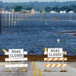
By now you are probably aware of the major flooding that happened over the last several days in Missouri. Larry Lazar gave us a guest post detailing his personal experiences in Eureka, where the flooding was extensive. This flooding is not over, but is simply moving down stream in the Mississippi watershed. It will take several days before this is over.
We are long past the days when one can honestly say “you can’t attribute a given weather event to climate change.” Climate is weather long term, and weather is climate in the here and now. Climate has changed because of anthropogenic global…
Despite the devastating storms across the country the last few weeks, NASA is forecasting the worst is yet to come. Michael Mann, author of "Dire Predictions: Understanding Climate Change" joins to discuss.
This is a guest post by Larry Lazar.
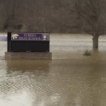
If you have had the news on the last day or two you may have seen stories and images about the Missouri floods. Many of those images are from Eureka (where we live), Pacific (where my wife Kellie works) and Valley Park (which is on my commute to work). That picture of the submerged McDonald's you may have seen on the news is in Union, Missouri, about 20 miles to the southwest of Eureka
We are dry, mostly, and doing okay. The basement was flooded during the initial 3 day rain event due to a failed sump pump and a couple downspouts that came unattached from…
I had considered writing an accounting of all the outlandish weather events of 2015, but that project quickly became a tl:dr list of untoward happenings which is both alarming and a bit boring, since it is so long. So, I decided to generate something less comprehensive, focusing more on the context and meaning of the diverse and impressive set of outcomes of anthropogenic global warming, an historically strong El Niño, and, well, weather which is already a pretty whacky thing.
See: Highlights of Climate Change Research in 2015
It should be noted right away that 2015 is the last year in which…
Sandra is a Category 4 hurricane in the Eastern Pacific. The storm will hit Mexico.
Sandra breaks several records. It is the first observed Category 4 hurricane on Thanksgiving Day. It is the latest major Western Hemisphere hurricane observed. It is the latest Category 4 storm in either the eastern Pacific of Atlantic basins. Most likely, Sandra will become the latest landfalling tropical cyclone on record for Mexico.
(Jeff Masters has details.)
Sandra will come near the southern time of the Baja late Friday, but will likely be a tropical storm at that point. The storm will come ashore…
Update: Saturday Morning
The storm is likely to start affecting land Sunday, and to make landfall late Sunday or some time Monday, probably as a Category I equivalent.
Meanwhile this is the first tropical storm I've ever seen associated on the Internet with sites that seem to want to plant viruses on your computer. Stick with trusted sources, like the Wonder Blog or Yours Truly.
Update Friday AM:
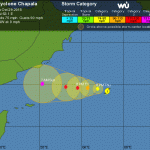
TC Chapala is expected to be the strongest cyclone ever recorded in this part of the Indian Ocean basin. At present the storm is strengthening and is just under Category 5 strength (it will…

CNN is calling Hurricane Patricia "The Most Dangerous Hurricane in History." Another news outlet showed a picture of the hurricane and pointed out "The Enormous Size of Hurricane Patricia."
Both of these are wrong. Size matters with hurricanes. A category 5 hurricane that is twice as large as another category 5 hurricane is "more dangerous" all else being equal, and by "all else" I mean things like exactly where it hits, how fast it is moving, exactly how strong it is (category 5 includes a very wide range of wind speeds because it is the highest category). Hurricane Patricia is not huge.…