Hurricane
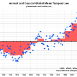
NOAA will announce today that 2014 was the warmest year during the instrumental record, which begins in 1880. The announcement, which addresses findings of both NOAA and NASA, will be made today at 11:00 Eastern. Below is the press release from NOAA.
I talked about this and other climate matters in a radio interview at Green Divas:
Michael Mann has made the following statements regarding this news:
2014 Was Earth’s Warmest Year On Record
Three major climate organizations (JMA, NASA, and NOAA) have now released their official estimates for the 2014 Global Mean Surface Temperature. Both JMA…
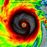
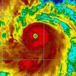
The outer reaches of Typhoon Hagupit are already affecting the target region in the Philippines. Hundreds of thousands of people have fled the areas most under the gun, but the potential for serious problems covers a very large area. The storm has gone through quite a few changes over the last couple of days, but is probably strengthening somewhat right now. No matter what happens, it is going to hit the Philippines as a very serious storm.
Jeff Masters has an update here.
This is the same area that was hit with Typhoon Haiyan last year. Haiyan was a bigger storm. But, Haiyan was also…
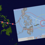
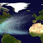
Super Typhoon Hagupit is on its way to the Philippines. The image above shows the storm track for Typhoon Haiyan, which was a very damaging super Typhoon that came through the same area last year, and served as an example of climate change making things worse. The smaller map is the Japan Meteorological Agency's prediction of Hagupit's path. They are very very similar.
Hagupit will not likely be as strong as Haiyan (see details here) because the region does not have the extra warm deep water that supercharged Haiyan. But Hagupit is still going to be a bad storm.
There has not been much hurricane activity in the Atlantic for a while now, so unsurprisingly the reporting is starting to slip again. This post goes out to all you reporters at CNN and Reuters and Yahoo and everywhere else. Imma give you an example of what you are doing wrong, then I'll send you to a place to learn up on it.
A recent report noted that "hurricane force winds are now bearing down on Bermuda, and the storm is expected to arrive within hours" meaning the eye would arrive within hours (paraphrased). This is not what is happening. When there is a hurricane arriving at your…
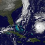
Atlantic Hurricane Gonzalo is a Major Hurricane, Category 3 at the moment, and it is heading towards Bermuda. The storm will weaken a little bit before getting there but it will still be major. This is a significant event. It is possible that a storm surge of about 10 feet could occur there. Gonzales will be very near Bermuda in by Friday Evening, and past it by Saturday morning.
Interestingly, Gonzalo is expected to remain a hurricane strength storm (though it may be called a "post-tropical cyclone" it will still have sustained winds at hurricane level) as it passes the Canadian…

Odile was the strongest hurricane to strike the Baja Peninsula during the period of available data, roughly similar to Hurrican Olivia (1967). The storm reached Category 4 strength but was then weakened because of interaction with the effects of a prior hurricane in the area (Norbert). At the moment, Odile is a tropical storm and still in the Baja. There was flooding, and two fatalities, including a lightning strike and a nine year old boy taken by floodwaters. Several building in Acapulco were damaged. There has been a lot of damage and disruption in the Baja region.
Tropical Storm Polo…
There is a major typhoon (hurricane) in the Western Pacific, Rammusan, which has already caused flooding and damage in the Phillipenes, where it killed 12 people, heading for southern China, and expected to affect northern Vietnam later on. From Accuweather:
Warm ocean waters combined with light wind shear will allow the storm to remain well organized through Friday as it approaches Hainan Island. Rammasun will likely bring widespread winds of 100 mph to northern Hainan Island on Friday afternoon and Friday night with higher gusts. Widespread wind damage is expected across northern Hainan,…
Update:
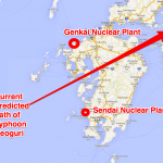
The new forecast track of Neoguri is shown above as well as the location of two nuclear power plants.
The forecast track has moved south, and is now in a very good (and here good means bad) position to strike the Sendai nuclear power plant very directly. Keep in mind that this forecast may change.
On Tuesday mid day UTC the storm will likely be in the later phases of a turn to the right, aiming roughly at the Sendai plant. At this point maximum wind speed near the center of the storm will likely be about 90 mph, which puts the storm in the middle of the Category One range. That…
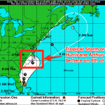
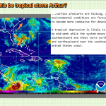
The Hurricane may (or may not) directly strike the Outer Banks.) I've updated the title of the post to update concern that Hurricane Arthur has a much increased chance of directly striking coastal regions in North Carolina. Scroll down to the most recent update below to find out more. I'm adding updates to a single post rather than writing new posts because I'm almost out of paper for blog posts. No, not really, it does not work that way. I'm doing this as an experiment in keeping things organized, especially handy-dandy images of the process unfolding.
The previously mentioned tropical…
Maybe yes, maybe no. Good chance, yes.
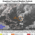
It is too early to call, but the blob I mentioned the other day has turned into a spiral and is starting to get organized. Forecasters at NOAA think there is an 80% chance this low pressure phenomenon will be a tropical storm by the 4th of July. They are also, somewhat vaguely, saying that it will move south, then northward, then northwest, which puts the storm off the coast of the US Mid-Atlantic or Southeast somewhere. Given that the storm is not moving in a consistent direction steered by well defined one directional forces, this should be very…
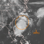
There is a stormy thing in the Atlantic that may become a Tropical Storm. It is really just a blob right now, but there is a roughly even chance that over the next two to five days it will form a tropical storm.
No matter what, this blob will menace the US east coast, though it is way too early to say if this will be a big deal or not. It is not entirely clear which direction it will be moving in over the medium term. We will be keeping and eye on it.
Usually when I make a sentence like that it is about my wife, Amanda. But this time we're talking about Hurricane Amanda, the first hurricane of the Eastern Pacific hurricane season.
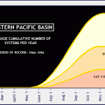
Amanda reached maximum winds of 155 mph on or about 8:00 AM Pacific Daylight Time on Sunday morning. That make Amanda the strongest Eastern Pacific May Hurricane on record. There are usually very few hurricanes in the Eastern Pacific in May, and the few that occur happen late in the months. Here's the historical distribution of Eastern Pacific hurricanes, form 1966-1996:
Amanda is the earliest on record…
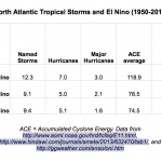
I have a little "science by spreadsheet" project for you, concerning the relationship between El Niño and Atlantic hurricanes.
The chance of an El Niño event happening this year seems to go up every few days, with most, perhaps all, climate models suggesting that El Niño will form this Summer or Fall. Climate experts tell us that there are typically fewer hurricanes in the Atlantic during El Niño years. So, I was interested to see how many fewer. Also, there appears to be a different kind of El Niño that happens sometimes, perhaps more often these days as an effect of global warming,…
The last hurricane season in the Atlantic was anemic, being one of least active periods on record. This was attributed to extra dust blown off the Sahara which inhibits hurricane development.
Right now, the various forecasting agencies around the world are agreeing that there is a greater than 50% chance, perhaps a 70% chance of an El Nino event happening this year, starting in the Summer or Fall. Traditionally, we think of El Nino events as inhibiting tropical storm and hurricane formation in the Atlantic. Today, a group that predicts hurricane activity in the Atlantic every year has used…

Update on Haiyan/Yolanda Death Toll
The final figures are not likely in but the numbers have stabilized and we can now probably put a number to the human toll of this storm that will not change dramatically in the future, at least in terms of orders of magnitude. The current “official” death toll in the Philippines from Typhoon Yolanda/Haiyan is 6,009 with 1,779 missing and 27,022 injured, with the largest concentration of casualties in Eastern Visayas. This comes from a December 13th report of the National Disaster Risk Reduction and Management Council, which you can (probably) download here…
Storm surges are amazing. I've never seen one happen but I've seen the aftermath. A video has surfaced of a storm surge hitting Hernani in Eastern Samar, shot from the second floor of a house that was a few hundred meters from the coast.
A storm surge is a mound of water caused by the wind of a hurricane (or other storm) pushing the water ahead of it, and further heightened by the low pressure system of the storm. In a given major storm there can be many, but there seems to be one big one most of the time. If the surge happens at high tide it is worse. If it happens at spring high tide…
Added:
The depression has spun up to form a tropical storm. It will probaqbly remain a storm as it works its way up the Atlantic Ocean avoiding land (though it seems to be aimed ultimately at Greenland). The storm is named Melissa.
Details here.
________________
We have had a record breakingly anemic hurricane season in the North Atlantic this year. How anemic? If this year's hurricane season was a rug, you'd have a floor. If this year's hurricane season was a car you'd have a bicycle. If this year's hurricane season was a stack of pancakes, you'd have one pancake. That's now anemic.…

While reading an AP attributed article on Huffington post about Super Typhoon Haiyan (also known as Yolanda), I did a double take at this paragraph:
Weather officials said Haiyan had sustained winds of 235 kilometers per hour (147 miles per hour), with gusts of 275 kph (170 mph), when it made landfall. By those measurements, Haiyan would be comparable to a strong Category 4 hurricane in the U.S., and nearly in the top category, a 5. Hurricanes, cyclones and typhoons are the same thing. They are just called different names in different parts of the world.
It struck me because "nearly in the…

Trigger warning: Truth and pain.
Published on Nov 11, 2013
Philippines delegate Naderev (Yeb) Saño, announces his decision to go on hunger strike on the first day of the COP19 Climate Change Summit in Poland, 11 November 2013.
Making an impassioned plea for action by the conference, he said that he would be fasting in solidarity with his country-folk until action to prevent climate change is forthcoming.
Saño received a standing ovation after describing the hardship suffered by Filipino's, including members of his own family, due to the "colossal" typhoon Haiyan which recently hit his…
Should there be a Category 6, or even a Category 7, to classify extra bit tropical cyclones like Haiyan?
Some tropical cyclones labeled Category 5 are much stronger than others. It has been suggested that we would be smart to extend the system to have a Category 6 and maybe even a Category 7 to allow the additional severity of these storms to be indicated when they are being spoken of in the news or by officials in charge of scaring people into doing the right thing, like running away or staying indoors.
There is resistance to this proposal that comes from two mostly distinct places. One is…