severe weather
I want to tell you about what may be the most important research result in the area of climate change in recent years. First, a little background.
We know from paleoclimate studies that the Earth's climate system changes from time to time enough to leave a mark. For example, it is widely thought that during the "ice ages" (periods of extensive or moderate glaciation) over the last couple of million years, areas that are currently very dry had a lot more water. Some combination of rain and evaporation (more rain and less evaporation) conspired to fill playas (dried up lakes) or salt lakes (…
Wed AM Update:
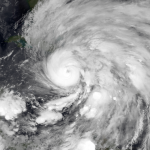
Meranti passed near the southern tip of Taiwan, and apparently it was pretty windy and nasty there. But, Taiwan has invested heavily in infrastructure with the idea of being hit with giant typhoons now and then, so things were not as bad as they could have been.
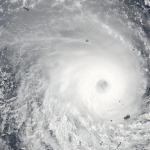
apparently Meranti is now a category 5 equivalent heading for China. The storm is expected to weaken only a bit as it makes landfall (see this post on what landfall means) so this is going to be a direct hit by a major hurricane. There are some pretty densely populated areas in the storm's path. There are also many…
Update: Mid Day Monday:
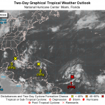
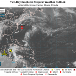
Ian is no longer a glimmer in the eyes of NWS forecasters. Ian is now a tropical storm. However, Ian is about to head north over unfavorable waters, will likely never develop hurricane strength, and is not expected to hit anything big. (See map above.)
Nothing else is really happening in the Atlantic at this time, wrt storms. There is a disturbance in the Lesser Antilles, which is not likely to do anything more any time soon, if at all.
Update: Monday AM:
Yes, the chances that a tropical storm that has been tracked for a few days now as a disturbance will form today…
Hurricanes are well defined systems with characteristics that quite literally set them apart from other storms. Large storms such as Nor'Easters are sometimes less well defined and interact more with major troughs, the jet streams, etc. We have come to understand Hurricanes as the worst case scenario, while other storms are less dangerous.
But sometimes, and I suspect more recently lately, these non-tropical storms become quite dangerous. The Great Storm of '78 killed hundreds in New England and made us suddenly realize that coastal property was a temporary thing. But we sense the danger…
Update (Sunday PM):
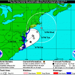
Hermine is still a big storm and will affect eastern regions to some degree, but the storm never reformed as a hurricane, and is not not expected to do so. Also, the storm has jinked out to the east more than expected and will likely move farther east. So, there will be some coastal effects, but not much out of the ordinary.
POST-TROPICAL CYCLONE HERMINE FORECAST/ADVISORY NUMBER 30
NWS NATIONAL HURRICANE CENTER MIAMI FL AL092016
2100 UTC SUN SEP 04 2016
CHANGES IN WATCHES AND WARNINGS WITH THIS ADVISORY...
A TROPICAL STORM WARNING HAS BEEN ISSUED FROM WATCH HILL…
Update (Noonish Friday):
Lester is going to skim along to the north of the Hawaiian Islands. This is an estimate of the probability of the distribution of 50mph winds:
Surf's up, it will be stormy, but the significant threat is moderate.
Update (Noonish Thursday):
Madeline sort of hit Hawaii, but it also did a funny little shrug as the medial to outer bands got close to the big island, and the rematerialized on the other side, keeping with the mysterious tradition (see below) of hurricanes magical avoiding the island state. But, the storm surge did in fact swamp a lot of places along the…
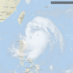
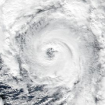
This is a huge hurricane/typhoon heading quickly, and imminently, towards taiwan.
The storm itself is roughly as wide as the island nation is long, so very little will be left unaffected.
The storm is at the very high end of the range of storms in size, strength, etc. It is currently equivalent to a Category 5 hurricane. It may weaken a bit before landfall over the next few hours, but it may remain a Category 5.
Winds, huge waves and coastal flooding from storm surges will be a big problem with this storm, but the largest problem may be the incredibly high rainfall, with about one meter of…
Weather is climate here and now, and climate is weather over the long term. Climate is the large scale process of movement of air and water, and changes in the properties of air and water, on and near the surface of the Earth, the atmosphere, oceans, and ice fields respond to the imbalance of heat -- with more of it near the equator and less of it at the poles -- as the world literally turns. Weather is the local, temporal, and personally observable sign of that climate system. Climate is meaning and weather is the semiotic process by which we understand that meaning.
OK, perhaps I've gone…
Update Monday June 6 AM: TropicalStorm Colin is heading for Florida.
The disturbance first noted a few days ago east of the Yucatan has moved across the mainland, into the eastern Gulf of Mexico, and with the relatively warm sea surfaces there as a source of inspiration, turned into Colin, a tropical storm.
Colin is not expected to become a hurricane, but it will make landfall somewhere on the Florida coast between, roughly, between Tallahassee and Tampa, tonight (Monday). The center of the current forecast is somewhere near Fish Creek and Steinhatchee, but that may change and this will be…
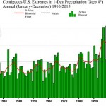
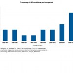
Trending wetter with time: weather never moves in a straight line, but data from NOAA NCDC shows a steady increase in the percentage of the USA experiencing extreme 1-day rainfall amounts since the first half of the 20th century. Photograph: NOAA NCDC
My Apology to Paul Douglas
I admit that I do a lot of Republican bashing. I'm a Democrat, and more than that, I'm a partisan. I understand that a political party is a tool for grass roots influence on policy, if you care to use it. The Democratic party platform, at the state and national level, reflects my policy-related values reasonably…
This year's Atlantic Hurricane season will be stronger, forecasts suggest, than that of the previous two years, and stronger than the average year.
The Atlantic Hurricane Seasons starts on June 1st. But, there was a hurricane that happened already, either late in last year's season or very early in this year's season, called Alex. That hurricane had to go somewhere, and I suppose the keepers of the records had already put their spreadsheet to bed when Alex came along on January 7th, so that storm gets counted as part of the season that will nominally start at the beginning of next month.…
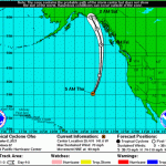
Tropical cyclone Winston is now a Category 4 storm and is probably going to make a direct hit on Fiji, tomorrow, Saturday. It will likely be a record storm for Fiji.
The storm is fueled by high sea surface temperatures, which extend to a significant depth, which probably caused the storm to intensify rapidly and to such a high state.
Jeff Masters and Bob Henson have written up the important information on this storm, here.
Fiji has been hit with a number of bad tropical storms, mainly concentrated in recent decades.
UPDATE (Friday PM Central)
Jeff Masters and Bob Henson are now…
GO HERE FOR THE LATEST UPDATE
See below for update
Jonas, (and no, I do not condone naming of storms that are not tropical cyclones) is going to do bad things to the US East Coast and hinterland.
Imma let you get back to setting your hair on fire over this storm, but first I want to 'splain something to you.
A big No'reaster like this is a big swirling fast moving low pressure system that is drawing potentially huge quantities of moisture off of a global warming and El Niño over-heated Atlantic ocean, driving that moisture inland where it will mix with cold air and turn into various forms of…
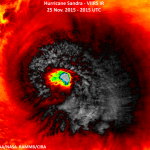
Sandra is a Category 4 hurricane in the Eastern Pacific. The storm will hit Mexico.
Sandra breaks several records. It is the first observed Category 4 hurricane on Thanksgiving Day. It is the latest major Western Hemisphere hurricane observed. It is the latest Category 4 storm in either the eastern Pacific of Atlantic basins. Most likely, Sandra will become the latest landfalling tropical cyclone on record for Mexico.
(Jeff Masters has details.)
Sandra will come near the southern time of the Baja late Friday, but will likely be a tropical storm at that point. The storm will come ashore…
Climate Change: What Everyone Needs to Know® by Joe Romm is just out, and is the most up to date examination of climate change science, the effects of climate change on humans, policy related problems, and energy-related solutions. Everyone should read this book, and if you teach earth system sciences you should consider using this book as a guide in your teaching, or in some cases, assigning it in class. The book is written to be read by general audiences, so it would work well in a high school or college setting.
As Romm points out, climate change will have more of an impact on humans,…
South Carolina Floods
I haven't said much about this partly because there is so much good coverage, but South Carolina's floods, still ongoing, are going to get on the list of worst weather events of 2015. Since these floods are amounting to a one in 1,000 year event, they are actually on the list of worst weather events since Vladimir the Great died, Cnut the Great invaded Enlgand (unrelated event), Eric Haakonsson outlaws berzerkers in Norway, and Olaf Haraldson declared himself King of Norway.
And yes, that event was climate change enhanced in at least two ways, maybe three. With global…
Pam is a tropical cyclone of category 5 strength, but is churning over waters that have high temperatures at depth, a phenomenon we seem to be seeing more often lately, as a result of anthropogenic global warming. That is why I call it "AGW Class." Strong Category 5, deep heat enhanced. It is said that this is one of only 10 Category 5 storms recorded in the basin since good data are available. The Weather Underground has the story.
In addition, there are three other tropical cyclones extant in the Pacific.
Nathan is just on the Tropical Storm-Hurricane boundary and is heading for Cape…
Human caused greenhouse gas pollution has warmed the planet. Global warming means more extreme weather. Many meteorologist who watch the weather every day see this. More and more research shows that greenhouse gas pollution changes the weather in a way that causes even more change in the weather. Changing weather systems means more lightning, increased high precipitation events in certain regions like the US Northeast, including more frequent large snow storms.
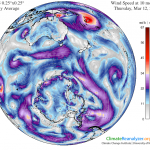
Global warming has had uneven effects. The Arctic has warmed relatively more than most of the rest of the planet. The major movements…
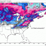
What happened to the Blizzard of 2015? Well, it happened. Despite breathless complaining about how the forecasters got it all wrong, they didn't. As the storm was predicted, there should have been close to about two feet of snow in the New York City metropolitan area, but as it turns out, there was between 8 and 12 inches. That means that New York City experienced a typical winter month's worth of snow in one day. Also, most snow that falls on The City falls a few inches at a time and melts more or less instantly, as few cities can match New York in its heat island effect. So, 8-12 inches…
The Blizzard continues. The center of the low pressure system moved to the northeast more than expected, so the maximum snowfall amounts have also moved deeper into New England, and it the storm may end up dropping the largest amounts Downeast, in Maine, rather than around New York and southern New England. Nonetheless maximum snow totals are heading for 20 inches in many areas west of Boston.
Here, I wanted to alert you to a recent study that talks about "Changes in US East Coast Cyclone Dynamics with Climate Change," which has this abstract:
Previous studies investigating the impacts of…