united states
First off, I wanted to thank all of the Eruptions readers for making January the most popular month ever on this blog. I suppose I should give an assist to Yellowstone, but really, thanks for coming to the blog, reading the posts and engaging in all the great discussions that go on within its (cyber)walls.
KÄ«lauea's east rift zone eruption site. Image courtesy of the USGS/HVO.
On to some news!
I suppose you've made the big time when you're in the New York Times, and sure enough, the current Yellowstone earthquake swarm is in the Old Grey Lady. Nothing much new to read, but summarizes the…
Some news for the last Friday in January:
Volcanic lightning captured over Redoubt in March 2009.
Tungurahua in Ecuador continues to erupt. Yesterday, the volcano spread ash over much of central Ecuador. Apparently people in Ecuador aren't taking the hazard of ash too seriously, with many ignoring recommendations to wear masks when the ash is falling. Over 50 explosions have been recorded over the last 24 hours at the volcano according to the Ecuadorian Instituto GeofÃsico, most of them small to moderate.
We also have a new USGS/Smithsonian Institute Volcano Activity Report. Much of the "…
Old Faithful geyser at Yellowstone National Park.
A few thoughts about faulting, earthquakes and eruptions:
The earthquakes at Yellowstone have been universally attributed to fault movement rather than magmatic activity by the USGS and the researchers at the University of Utah. This is likely based on the moment solutions for the earthquakes (i.e., the sense of motion on the earthquake - side to side, dilation, etc.) and the fact that there are no directly correlative volcanic/magmatic symptoms to go with them (such as pronounced, short-term bulging, excessive hydrothermal venting, etc.) Now…
Two quick notes:
A Costa Rican farmer evacuating in early January 2010 after renewed activity of Volcan Turrialba.
Well, it appears that after a quiet night on Friday, the current Yellowstone swarm picked up where it left off. We're now up to 1,200 earthquakes since January 17th, with a pair over M3 today. Of course, people are still uppity about the swarm, especially after the earthquake in Haiti, but really, they're about as connected as worrying about the rainy day in Boston when there was a typhoon in Malaysia. Just to get people on the same page, YVO still says: "The swarm events are…
Outcrops of Obsidian Butte, California, near the Salton Sea.
A brief update on the two earthquake swarms making news right now:
Yellowstone
The earthquake swarm at Yellowstone is still rumbling along, reaching over 1,000 earthquakes measured over the last week. However, the swarm has begun to die down overnight - with no earthquakes between 10:41 PM (MST) on 1/22 and 6 AM on 1/23. However, although this is a longer, bigger swarm than normal, it still isn't out of the regular rumblings at Yellowstone caldera. The USGS continues to say this swarm is tectonic, rather than magmatic or…
Quick news updates for a Wednesday...
The island (and volcano) of Gran Canaria in the Atlantic Ocean. It last erupted in ~20 B.C.
The earthquakes keep coming at Yellowstone - up to a M3.5 in the last 24 hours. Time has already put up an article wondering about whether people need worry about the swarm (there might be other things to worry about before this swarm). YVO's statement on the earthquake swarm seems pretty standard (as it should be): "At this time the Yellowstone Volcano Observatory does not consider the swarm to be unusual and the earthquakes are likely related to tectonic fault…
A hot spring in Yellowstone National Park. Image courtesy of the USGS.
Yesterday I left a little teaser about the current earthquake swarm going on at the Yellowstone Caldera. Eruptions readers have come through with even more information on the swarm. Over 250 earthquakes have occurred in the park over the last few days, most between 0.5-3.1 on the Richter Scale - and getting larger each day. The swarm is centered 10 miles northwest of Old Faithful, Wyoming and 9 miles southeast of West Yellowstone. However, before everyone gets too excited, Dr. Robert Smith of University of Utah (the go-to…
The collapse pit within the Halema`uma`u Crater at Kilauea taken January 7, 2010. Image courtesy of the USGS/HVO.
Eruptions reader Boris Behncke pointed out that things are afoot in the Halema`uma`u Crater at Kilauea. To steal his description: " the lava lake returned triumphantly to the active pit last night, and now it is filling virtually the entire field of the
Halema'uma'u Overlook webcam." Sure enough, checking out the webcam this morning, the field of view is dominated by a lava lake - albeit somewhat crusted over by hardened basalt lava. You can compare the current image with one…
Part 1 / Part 2 / Part 3 / Part 4
In Quentin Skinner's celebrated history The Foundations of Modern Political Thought he writes that:
If the history of political theory were to be written essentially as a history of ideologies, one outcome might be a clearer understanding of the links between political theory and practice.
In Part II of this series I highlighted how a common objection to the political theory of social Darwinism is that it was a misapplication of Darwin's science to already existing ideas. A second objection is that there is no core theoretical framework that would make the…
The weekend! No updates until next Tuesday - I'll be off to give a talk at Western Michigan University.
Coal-erupting volcanoes defeat the Permian dinosaurs ... according to FOX News.
Anyway...
You know that mainstream media (FOXNews) must have done something appalling when even I can't write about it thanks to my seething rage. I'll let Chris Rowan at Highly Allochthonous and Ralph at the Volcanism Blog sum up how FOX News tried to explain the extinction of the dinosaurs (hint 1: it happened before dinosaurs even existed. hint 2: volcanoes erupt coal now).
After you've read about that…
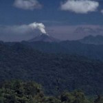
Two volcanoes down, two volcanoes up!
Fire fountain on Nyamuragira in the Congo, January 2010.
Down
Mayon
Activity at Mayon has continues to drop - although PHIVOLCS warns that an eruption could happen at any moment and without much warning. About a quarter of the evacuated families have no returned home since PHIVOLCS gave the OK to return home on January 2 - but Philippine officials are still on alert in case evacuations have to be reinstated.
Redoubt
The resurgent Redoubt is no long ... er ... resurging? AVO lowered the alert status to Green - meaning normal/background levels of activity…
A pile of news for the new week!
The glow of new lava flows from Nyamuragira in the Congo, taken from the Virunga Park Headquarters, January 2, 2010.
Mayon
PHIVOLCS may lower the alert status at Mayon to Level 2 after almost a week of lower seismicity and no ash explosions since December 29th. Schools that were being used as evacuation centers were also returned to teachers and students for the start of classes after the Christmas holiday. However, the Albay provincial government is now considering a plan to permanently move everyone who lives within the 6-km danger zone around Mayon, even…
Here it is, my attempt to recap a year's worth of volcanic events. By no means is this supposed to capture every event, but rather the highlight/lowlights and what most captivated me during 2009. I'll be announcing the winner of the 2009 Pliny for Volcanic Event of the Year tomorrow.
Waimangu Geothermal Valley in New Zealand, taken in January 2009 by Erik Klemetti.
January
The year started out with a trip to New Zealand (well, for me at least) and vistas of the Waimangu Valley, formed in the 1886 eruption of Tarawera on the North Island. We were also still thinking about the late 2008…
Not much new to report today, so I'll just add some notes to the two volcanoes in the news right now: Mayon and Redoubt.
Mt. Redoubt in Alaska, taken on September 23, 2009. Image courtesy of AVO/USGS, taken by Game McGimsey.
Mayon:
The volcano continues to show signs that a major eruption is in the works, but nothing new occurred over the last 24 hours. 2 km / ~5,000 foot ash plumes were produced from the new dome/flow complex, causing a potential aviation hazard, and the lava flows continued to be erupted. In evacuation news, animals are now being evacuated from the hazard zone around the…
The most recent image on the AVO website of the dome at Redoubt, taken in November 2009. Image courtesy of AVO/USGS, by Cyrus Read.
Not much information on this, but AVO just raised the alert status at Redoubt in Alaska to Yellow for the first time since late September. A series of small earthquakes were detected near the summit dome starting at 10 A.M. today, prompting the change of status.
The link to the complete text of the change in status doesn't seem to work on the AVO site, so here it is:
2009-12-28 09:53:11 - VAN/VONA
AVO is raising the Aviation Color Code to YELLOW and the Volcano…
It's the last week of classes and it's also AGU (which I will be missing for the first time in 5 years). If you happen to be at the big meeting in SF and hear something you think we'd like to hear, feel free to drop me a line or leave a comment so we can live vicariously through you.
Pyroclastic flows at Sourfriere Hills, December 2009. Image courtesy of MVO.
Some news:
UPDATE 12:40PM 12/14/2009: Just to update the Mayon news from earlier today, PHIVOLC is reporting that lava has been spotting flowing from the main crater on Mayon. Sounds like the eruption we've been waiting for is…
Some news for today:
Yellowstone National Park, USA.
Another fine example of media headline versus actual research, an article in the Jackson Hole Daily about a new study by Dr. Robert Smith and others on the Yellowstone plume was titled "Park's giant magma plume eating up mountains". Yikes! Well, the actual study published recently in the Journal of Volcanology and Geothermal Research is more about the geophysical parameters of the Yellowstone plume - a plume that might reach as far as 500 km below the caldera itself. As for the mountain eating part, I think they were trying to get at the…
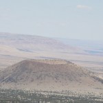
Well, this MVP was a bit trickier than most, thanks to the fact that most scoria/cinder cones look pretty similar and some initial confusion about the photo in the first place. Anyway, lets review!
The photo:
It was identified by the sender as Missouri Bill Hill in Arizona. However, this doesn't seem to be the case.
From Google Earth, Missouri Bill Hill:
After close examination by me and all of you, it seems that the consensus is that it is, in fact, Antelope Hill in Arizona - both near each other in the same volcanic field.
From Google Earth, Antelope Hill:
This leaves me confident that…
Its already Friday!
News!
Print of the Temple of Jupiter at Pompeii with a steaming Vesuvius in the background.
You can now wander down the streets of ancient Pompeii from the comfort of your own home or office. Google Streetview now cover the streets of the city wiped out by the 79 A.D. eruption of Vesuvius in Italy. Now, some of the articles on the Pompeii streetview give lipservice to the current threat of Vesuvius to the modern city of Naples, my favorite being:
The authorities continually monitor Vesuvius these days, and estimate they'll be able to give adequate warning if it's ever in…
It has been a slow week for volcano news (and a busy week for me), so I apologize for the abundance of MVPs this week. I've tried to find a good one in the many images submitted to me by Eruptions readers, and #15 is just one of those photos. If you have images you'd like to share with me for MVP or other uses, please email them to me at
. (However, I should note that you can't win by identifying your own volcano photo!)
MVP #13 was Lava Butte near Newberry volcano in Oregon. It is a lovely small scoria cone that you can walk/drive to the summit. From there, you get a spectacular view of the…